 Map of the English Lake District

|

|
|
|
map type:- Stanford 1880 |
|
|
|
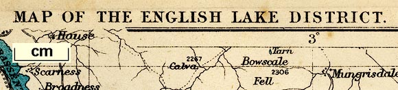
Map of the English Lake District, scale about 4 miles to
1 inch, by Edward Stanford, Stanford's Geographical
Establishment, 55 Charing Cross, London, 1880?.
Folded and tipped in as frontispiece to the Tourist's Guide to the English Lake District, by Henry Irwin Jenkinson. A large version of this map, 1 inch to 1 mile, was sold separately by Edward Stanford, 55 Charing Cross, London, from 1886. |
||
|
(example map JandMN (151_1))
|
||
| map feature:- | up is N & scale line & lat and long scales & lat and long grid & rivers & lakes & county & settlements & roads & railways | |
| inscription:- |
printed top
MAP OF THE ENGLISH LAKE DISTRICT |
|
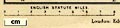
| inscription:- |
printed above scale line
ENGLISH STATUTE MILES |
|
| wxh, sheet:- | 16.5x21.5cm | |
| wxh, map:- | 145x188mm | |
| scale line:- | 8 miles = 51.1 mm | |
| scale:- | 1 to 250000 ? (1 to 251952 from scale line) | |
|
||
| sources:- |
JandMN Collection |
|
| items seen (illustrated items in bold):- | ||

|
JandMN (151_1) -- map -- Map of the English Lake District | |
|
|
private collection (289) -- map -- English Lake District | |