 Stanford 1880

|

|
|
|
item:- private collection (289) image:- © see bottom of page |
click to enlarge |
|
|
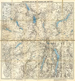
Map, colour lithograph, the English Lake District, scale
about 1 inch to a mile, publishd by Edward Stanford, 55
Charing Cross, London, 1886.
The map is a large version of that included in a Tourist's Guide to the English Lake District, by Henry Irwin Jenkinson. |
||

|
Stanford 1880 | |
| map feature:- | card cover & sectioned for folding & mounted & folded (6X4) & up is N & scale line & sea plain & coast line & foreshore sands & rivers & lakes & relief & contours & spot heights & woods & forests & parks & county & settlements & roads & railways | |
| inscription:- |
printed top
STANFORD'S MAP OF THE ENGLISH LAKE DISTRICT. |
|
| inscription:- |
printed bottom right, centre
Stanford's Geographical Establishment / London : Published by Edward Stanford, 55, Charing Cross, 2nd. March 1886. |
|
| inscription:- |
printed bottom
The broken lines engraved on this map [dotted line] / are the footpaths and tracks described in / "Jenkinson's Guide to the English Lakes." |
|
| inscription:- |
printed with scale line
Scale. One Inch to One Statute Mile. |
|
| scale line:- | 3+1 miles = 101.5 mm (approx) | |
| scale:- | 1 to 63000 ? (1 to 63422 from scale line) | |
| wxh, cover:- | 13x20cm | |
| wxh, sheet:- | 72x77.5cm | |
| wxh, map (with large gaps):- | 69.5x73cm | |
|
||
|
||