 Smith 1822

|

|
|
|
map type:- Smith 1822 |
|
|
|
Maps, Westmoreland, scale about 5.5 miles to 1 inch, and
Cumberland? by Charles Smith, engraved by Pickett, published
by Charles Smith, 172 Strand, London, 1822.
Published in 'Smith's New English Atlas, being a reduction of his large folio atlas Containing a Complete set of County maps on which are Delineated All the Direct & principal Cross Roads, Cities, Towns, & most considerable Villages, Parks, Rivers, and Navigable Canals: Preceded by A General Map of England and Wales. The whole carefully Arranged according to the Stations & Intersections of the Trigonometrical Survey of England. London: Printed for C. Smith, Mapseller extraordinary To His Majesty No.172, Strand, 1822.' The atlas size is 8 7/8 x 11 ins. |
||
|
(example Armitt Library : ALMC2008.14.69)
|
||
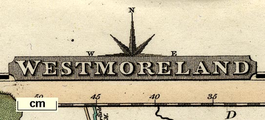
| map feature:- | title cartouche & compass rose & up is N & scale line & lat and long scales (trapezoidal projection?) & sea shaded (?) & coast line & rivers & lakes & relief & hill hachuring & forests & parks & county & settlements & roads & road distances & distances from London & canals | |
| inscription:- |
printed title cartouche, top
WESTMORELAND |
|
| inscription:- |
printed bottom
Printed for C. Smith, No.172 Strand, 1822. |
|
| wxh, sheet:- | 28x22.5cm | |
| wxh, map:- | 233x185mm | |
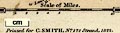
| inscription:- |
printed above scale line
Scale of Miles. |
|
| scale line:- | 10 miles = 46.8 mm | |
| scale:- | 1 to 340000 ? (1 to 343877 from scale line assuming a statute mile) | |
|
||
| references:- |
Smith, Charles: 1822: Smith's New English Atlas: (London) |
|
| sources:- |
Chubb 1927 (CCCLXXXVIII) Armitt Library |
|
| items seen (illustrated items in bold):- | ||

|
Armitt Library : ALMC2008.14.69 -- map -- Westmoreland | |
|
|
Carlisle Library : Map 184 -- map -- Westmoreland | |