 Smith 1822

|

|
|
|
item:- Armitt Library : ALMC2008.14.69 image:- © see bottom of page |
click to enlarge |
|
|
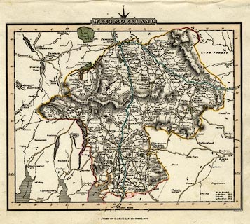
Map, hand coloured engraving, Westmoreland ie
Westmorland, scale about 5.5 miles to 1 inch, by Charles
Smith, engraved by Pickett, published by C Smith, 172
Strand, London, 1822.
Included in Smith's New English Atlas. Roads are differentiated by the tints - two major routes, post routes? are cyan; other main roads, turnpikes? are pale brown; the rest are not tinted. |
||

|
Smith 1822 | |
| map feature:- | compass rose cartouche & compass rose & up is N & scale line & lat and long scales (trapezoidal projection?) & sea shaded (?) & coast line & rivers & lakes & relief & hill hachuring & forests & parks & county & settlements & roads & road distances & distances from London & canals | |
| inscription:- |
printed title cartouche, top
WESTMORELAND |
|
| inscription:- |
printed bottom
Printed for C. Smith, No.172 Strand, 1822. |
|
| inscription:- |
printed above scale line
Scale of Miles. |
|
| scale line:- | 10 miles = 46.8 mm | |
| wxh, sheet:- | 28x22.5cm | |
| wxh, map:- | 233x185mm | |
| scale:- | 1 to 340000 ? (1 to 343877 from scale line assuming a statute mile) | |