 Pinnock 1833-34

|

|
|
|
map type:- Pinnock 1833-34 |
|
|
|
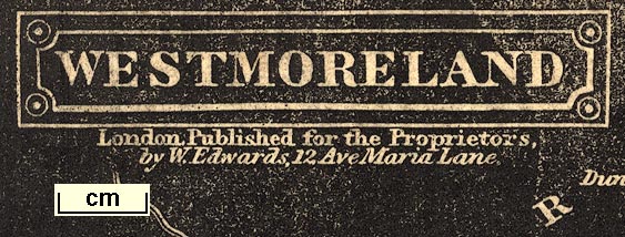
Maps, Westmoreland, scale about 6 miles to 1 inch, and
Cumberland, scale about 8 miles to 1 inch, engraved by J
Archer, published by William Edwards, Ave Maria Lane,
London, 1833-34.
Published in Pinnock's Guide to Knowledge; Westmoreland 1834, Cumberland 1833. |
||
|
(map example JandMN (142))
|
||
| map feature:- | title cartouche & coat of arms & north point & up is N & scale line & lat and long scales & sea plain & coast line & rivers & lakes & relief & hill hachuring & county & settlements & roads | |
| inscription:- |
upper left
WESTMORELAND |
|
| inscription:- |
printed
head of page, right of map |
|
| inscription:- |
below title cartouche
London. Published for the Proprietors, / by W. Edwards, 12 Ave Maria Lane. |
|
| inscription:- |
printed lower right
J. Archer sc. |
|
| wxh, sheet:- | 19x25.5cm | |
| wxh, map:- | 231x166mm | |
| inscription:- |
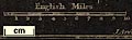
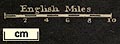
printed above scale line
English Miles |
|
| scale line:- | 10 miles = 42.6 mm | |
| scale:- | 1 to 380000 ? (1 to 377780 from scale line assuming a statute mile) | |
|
||
|
||
| sources:- |
JandMN Collection Armitt Library |
|
| items seen (illustrated items in bold):- | ||

|
Armitt Library : ALMC2008.14.126 -- map -- Westmoreland | |
|
|
Carlisle Library : Map 161 -- map -- Cumberland | |
|
|
JandMN (142) -- map -- Westmoreland | |
|
|
JandMN (143) -- map -- Cumberland | |