 Pinnock 1833-34

|

|
|
|
item:- JandMN (143) image:- © see bottom of page |
click to enlarge |
|
|
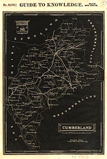
Maps, reversed out, white on black, Cumberland, scale
about 8 miles to 1 inch, engraved by J Archer, 100 Drummond
Street, Euston Square, published by William Edwards, Ave
Maria Lane, London, 1833.
Included in Pinnock's Guide to Knowledge, no.47, 1833. |
||

|
Pinnock 1833-34 | |
| map feature:- | white on black & plain cartouche & coat of arms & up is N & scale line & lat and long scales & sea plain & coast line & rivers & lakes & county & settlements & roads | |
| inscription:- |
lower right
CUMBERLAND |
|
| inscription:- |
printed
head of page, above map |
|
| inscription:- |
below title cartouche
London. W. Edwards, Ave Maria Lane. |
|
| inscription:- |
printed lower right
J. Archer sc. 100 Drummond St Euston Sq |
|
| inscription:- |
printed above scale line
English Miles |
|
| scale line:- | 10 miles = 32.1 mm | |
| wxh, sheet:- | 19.5x26.5cm | |
| wxh, map:- | 164x229mm | |
| scale:- | 1 to 500000 ? (1 to 501353 from scale line assuming a statute mile) | |