 Piggot 1835

|

|
|
|
map type:- Pigot 1835 |
|
|
|
Maps, Westmoreland, scale about 10 miles to 1 inch, and
Cumberland? engraved by Pigot and Slater, Manchester,
published by Pigot and Co, Manchester and London, about
1835; published 1835-42.
Published in vol.1 of 'A POCKET TOPOGRAPHY AND GAZETTEER OF ENGLAND: WITH HISTORICAL AND STATISTICAL DESCRIPTIONS, AND DISTANCE, PAROCHIAL, POPULATION, & OTHER Tables. ILLUSTRATED BY MAPS OF THE ENGLISH COUNTIES, AND VIGNETTES OF CATHEDRALS AND CHURCHES. BY PIGOT & CO. COMPILERS AND PUBLISHERS OF DIRECTORIES FOR THE WHOLE OF THE UNITED KINGDOM. IN TWO VOLUMES. VOL. I. / LONDON: PIGOT & CO. FLEET-STREET; LONGMAN & CO. AND SHERWOOD & CO. PATERNOSTER-ROW, AND SIMPKIN AND MARSHALL, STATIONER'S-COURT; AND PIGOT AND SLATER, FOUNTAIN STREET, MANCHESTER. Price, each Volume, 12s. 6d.' 1835. The accompanying page has an engraving of Holy Trinity Church, Kendal, and a table of distances for the county. Published in another edition 1842. |
||
|
(example map Armitt Library : ALMC2000.14.41)
|
||
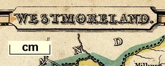
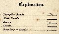
| map feature:- | title cartouche & north point & up is N & scale line & lat and long scales (rectangular projection? the longitude scale jumps 5 minutes across the piece hidden by cartouches) & table of symbols (includes railroads) & sea plain & coast form lines & rivers & lakes & forests & county & settlements & roads (turnpike roads) & canals | |
| inscription:- |
printed title cartouche, top
WESTMORELAND. |
|
| wxh, sheet:- | 12.5x19.5cm | |
| wxh, map:- | 165x104mm | |
| inscription:- |
printed above scale line
Scale of Miles. |
|
| scale line:- | 10 miles = 25.9 mm | |
| scale:- | 1 to 620000 ? (1 to 621368 from scale line assuming a statute mile) | |
| longitude, Kendal:- | 2d 55m W (?) | |

|
||
|
||
| references:- |
Pigot and Co: 1835 & 1842: Pocket Topography and Gazetteer
of England: Pigot and Co (London and Manchester) & Longman
and Co & Sherwood and Co & Simpkin and Marshall & Pigot and
Slater |
|
| sources:- |
Chubb 1927 (CCCCLXII) Armitt Library |
|
| items seen (illustrated items in bold):- | ||

|
Armitt Library : ALMC2008.14.41 -- map -- Westmoreland | |
|
|
JandMN (335) -- map -- Westmoreland | |