 OS One Inch map Popular edition & map

|

|
|
|
map type:- OS 1918 Popular Edition |
|
|
|
Map series, One Inch Popular edition maps of Great
Britain, scale 1 inch to 1 mile, published by the Ordnance
Survey, Southampton, Hampshire, from about 1918 onwards.
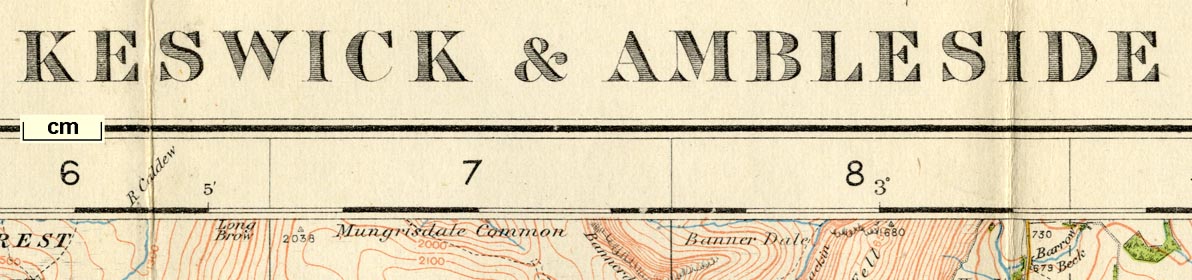
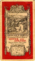
This edition is between the 4th and 5th editions. The maps were headed Outline edition to 1924 then Popular edition. Colour printed; contours; alphanumeric index grid. The sheets that concern Westmorland, Cumberland, and the parts of Lancashire north of the sands, and of Yorkshire, that became Cumbria are:- sheet 5 - Solway Firth and River Esk sheet 6 - Hexham sheet 8 - Workington and Cockermouth sheet 9 - Carlisle sheet 10 - Alston and Weardale sheet 12 - Keswick and Ambleside sheet 13 - Kirkby Stephen and Appleby sheet 18 - Wasdale sheet 19 - Windermere and Ulverston sheet 20 - Kirkby Lonsadle and Hawes sheet 24 - Lancaster and Barrow |
||
|
||

|
||
|
||
| references:- |
Hellyer, Roger: 1999: Ordnance Survey Small Scale Maps:
Archer, David (Kerry, Montgomeryshire):: ISBN 0 9517579 5
4 |
|
| sources:- |
JandMN Collection |
|
| sources:- |
|
|
| items seen (illustrated items in bold):- | ||

|
Carlisle Library : Map 354 -- map -- Lancaster and Barrow | |
|
|
JandMN (198) -- map -- Solway Firth and River Esk | |
|
|
JandMN (199) -- map -- Hexham | |
|
|
JandMN (200) -- map -- Workington and Cockermouth | |
|
|
JandMN (201) -- map -- Carlisle | |
|
|
JandMN (202) -- map -- Alston and Weardale | |
|
|
JandMN (203) -- map -- Keswick and Ambleside | |
|
|
JandMN (204) -- map -- Kirkby Stephen and Appleby | |
|
|
JandMN (205) -- map -- Wasdale | |
|
|
JandMN (206) -- map -- Windermere and Ulverston | |
|
|
JandMN (207) -- map -- Kirkby Lonsdale and Hawes | |
|
|
JandMN (208) -- map -- Lancaster and Barrow | |
|
|
JandMN (209) -- map -- Ribblesdale | |