 OS 1918 Popular Edition

|

|
||
|
item:- JandMN (198) image:- © see bottom of page |
click to enlarge |
||

|
index to OS 1918 sheets | ||
|
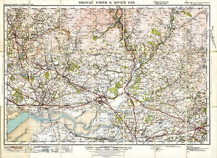
Map, colour printed, Solway Firth and River Esk, scale 1
inch to 1 mile, Popular Edition sheet 5, published by the
Ordnance Survey, Southampton, Hampshire, 1919-26, revised to
1931.
Parts of Dumfriesshire and Roxburghshire, Scotland, and Cumberland, England. The back cover is missing. |
|||
|
|
OS 1918 Popular Edition | ||
| map feature:- | sectioned for folding & mounted & folded (7x3) & card cover & location map (cover) & table of symbols & north point & magnetic deviation & up is N & scale line & lat and long scales & index grid & foreshore sands & coast line & rivers & relief & contours & spot heights & woods & forests & parks & county & settlements & roads & railways & canals | ||
| inscription:- |
printed top
ORDNANCE SURVEY OF GREAT BRITAIN / SOLWAY FIRTH & RIVER ESK / POPULAR EDITION ONE-INCH MAP / SHEET 89 Scotland, (Dumfriesshire & Roxburghshire) / sheet 5 England (Cumberland) |
||
| inscription:- |
printed cover
ENGLAND 5 / SCOTLAND 89 / ORDNANCE SURVEY / Contoured Road Map of / SOLWAY FIRTH / and RIVER ESK / Popular Edition, Mounted in Sections / Scale : 1 Inch to 1 Mile. Price 4/- black and red on pale brown; Ellis Martin design; picture of a walker on a hillside |
||
| wxh, folded:- | 11.5x19.5cm | ||
| wxh, sheet:- | 77x58cm | ||
| scale:- | 1 to 63360 ? (nominal) | ||

|
|||