 OS 1881-82 New Series

|

|
|
|
map type:- OS 1881-82 New Series |
|
|
|
Maps, parts of Westmorland, Cumberland etc, New Series 1
inch maps of England, scale 1 inch to 1 mile, published by
the Ordnance Survey, London, 1881-82.
As the mapping was already on the projection for the New Series, the Cassini Projection, the Old Series sheets 'outline edition' were renumbered to become the New Series. The new numbers are for quarter sheets, and runs left to right, north to south, for the whole of England and Wales. Cumbria appears on sheets:- 7, 11, 12, 16..19, 22..25, 28..31, 37..40, 47..50, 58; from the small index diagram available the old county sheets are for:- Westmorland, quarter sheets:- 24, 25, 29..31, 38..40, 49. Cumberland, quarter sheets:- 7, 10..12, 16..19, 22..24, 37, 38, 47, 48. Lancashire North of the Sands, quarter sheets:- 38, 48, 49, 58. Yorkshire around Sedbergh, quarter sheets:- 39, 49, 50. Published in a 'black hachured edition', also a renumbered version of the Old Series sheets. |
||

|
OS 1840s-60s Old Series | |
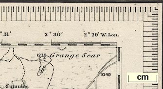
| map feature (early states):- | scale line & up is N & sea plain & coast form lines & rivers & lakes & relief & hill hachuring & contours & woods & forests & parks & county & settlements & roads & turnpike roads (gates marked) & canals & railways | |
| wxh, map (full size sheets):- | 77.5x62cm (approx) | |
| scale:- | 1 to 63360 ? (nominal) | |
|
||
|
||
| references:- |
Hellyer, Roger: 1999: Ordnance Survey Small Scale Maps:
Archer, David (Kerry, Montgomeryshire):: ISBN 0 9517579 5
4 |
|
| sources:- |
|
|
| sources:- |
JandMN Collection (one sheet) |
|
| items seen (illustrated items in bold):- | ||
|
|
JandMN (61) -- map -- Kendal | |