 OS 1881-82 New Series

|

|
|
|
item:- JandMN (61) image:- © see bottom of page |
click to enlarge |
|
|
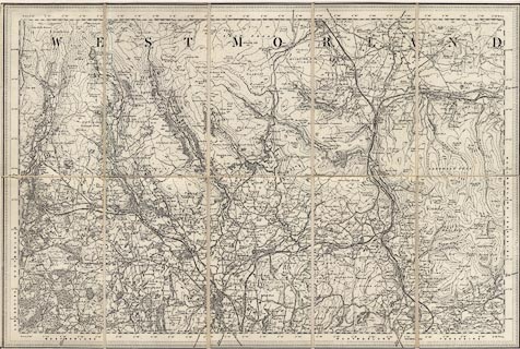
Map, engraving, area north of Kendal, Westmorland, New
Series one inch map, outline edition, sheet 39, scale 1 inch
to 1 mile, published by the Ordnance Survey, Southampton,
Hampshire, 1881-82.
The map includes Kendal and part of Westmorland, and Sedbergh and part of Yorkshire. It is a renumbered print of the equivalent Old Series one inch map of the 1860s. |
||

|
OS 1881-82 New Series | |
| map feature:- | sectioned for folding & mounted & folded (with end cards for protection) & piano key border (4 edges) & table of symbols (pasted on reverse) & up is N & scale line (printed on the retailer's label) & lat and long scales & rivers & lakes & relief & contours & woods & forests & county & settlements & roads & railways & canals | |
| inscription:- |
printed label on end card
SOLE AGENT BY APPOINTMENT FOR THE SALE OF ORDNANCE MAPS. / NEW 1 INCH ORDNANCE SURVEY OF ENGLAND AND WALES / SHEET 39 / ... / LONDON : EDWARD STANFORD, WHOLESALE & RETAIL MAP SELLER, &c., 26 & 27 COCKSPUR ST., CHARING CROSS, S.W. |
|
| scale line:- | 2 miles = 50.6 mm | |
| scale:- | 1 to 63360 ? (nominal) | |
| wxh, sheet:- | 51x34cm | |
| wxh, map:- | 51x34cm (approx) | |
| wxh, folded:- | 10.5x17cm | |