 Map of XVII Century England

|

|
|
|
map type:- Ogilby 1930 |
|
|
|
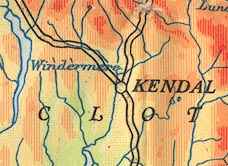
A Map of XVII Century England, including Westmorland,
Cumberland etc, in particular showing the routes mapped by
John Ogilby, 1675, scale about 16 miles to 1 inch, published
by the Ordnance Survey, Southampton, Hampshire, 1930.
|
||
|
(map example JandMN (35))
|
||
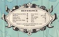
| map feature:- | folded & card covers & picture frame border & scale line & table of symbols & lat and long scales & lat and long grid & sea tinted & depth contours & coast line & rivers & relief & layer colouring & table of heights & settlements & roads | |
| inscription:- |
printed top
ODNANCE SURVEY MAP OF XVII CENTURY ENGLAND |
|
| inscription:- |
printed cover
A / Map of / XVII CENTURY / ENGLAND / WITH / Description, Chronological Tables, and / a Map of LONDON circa 1660. / Scale : 16 Miles to One Inch / Published by the / ORDNANCE SURVEY, / SOUTHAMPTON. / PRICE FIVE SHILLINGS black on buff; portaits of Charles and Oliver Cromwell |
|
| scale line:- | 100+10 miles = 178.1 mm | |
| scale:- | 1 to 1000000 ? (nominal) | |
| wxh, sheet:- | 64.5x85cm | |
| wxh, map:- | 583x772mm | |
|
||
| sources:- |
JandMN Collection |
|
| items seen (illustrated items in bold):- | ||

|
JandMN (35) -- road map -- Map of XVII Century England | |