 Ogilby 1930

|

|
|
|
item:- JandMN (35) image:- © see bottom of page |

click to enlarge |
|
|
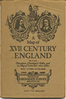
Map, colour printed, A Map of XVII Century England,
including Westmorland, Cumberland etc, in particular showing
the routes mapped by John Ogilby, 1675, scale about 16 miles
to 1 inch, published by the Ordnance Survey, Southampton,
Hampshire, 1930.
Various sources were used to compile the map, but most importantly the road strip maps of John Ogilby published in Britannia, London, 1675. |
||

|
Ogilby 1930 | |
| map feature:- | folded & card cover & colour printed & picture frame border & scale line & table of symbols & lat and long scales & lat and long grid & sea tinted & depth contours & coast line & rivers & relief & layer colouring & table of heights & settlements & roads | |
| inscription:- |
printed top
ORDNANCE SURVEY MAP OF XVII CENTURY ENGLAND |
|
| inscription:- |
printed cover
A / Map of / XVII CENTURY / ENGLAND / WITH / Description, Chronological Tables, and / a Map of LONDON circa 1660. / Scale : 16 Miles to One Inch / Published by the / ORDNANCE SURVEY, / SOUTHAMPTON. / PRICE FIVE SHILLINGS black on buff; portaits of Charles and Oliver Cromwell |
|
| scale line:- | 100+10 miles = 178.1 mm | |
| scale:- | 1 to 1000000 ? (nominal) | |
| wxh, sheet:- | 64.5x85cm | |
| wxh, map:- | 583x772mm | |
|
||