 Map of the North Eastern Railway and Connections

|

|
|
|
map type:- North Eastern Railway 1900s |
|
|
|
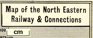
Railway map, Map of the North Eastern Railway and
Connections, scale about 15 miles to 1 inch, published by
the NER about 1900s?
Shows railways in Scotland, Northumberland, Durham, and parts of North Yorkshire, Cumberland and Westmorland.Those in Cumbria belonging to the NER are - Newcastle and Carlisle Railway and Alston branch, South Durham and Lancashire Union Railway, and Eden Valley Railway. NER running powers over the Cockermouth, Keswick and Penrith Railway are indicated. From a guide book. |
||
|
(example map JandMN (338))
|
||
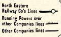
| map feature:- | table of symbols & plain cartouche & up is N & sea shaded & coast line & rivers & lakes & relief & hill hachuring & spot heights & settlements & railways | |
| inscription:- |
printed title cartouche, upper right
Map of the North Eastern / Railway & Connections |
|
| inscription:- |
printed bottom
MAP OF THE NORTH-EASTERN RAILWAY AND ITS CONNECTIONS. / Showing the accessibiility of the places described in this Handbook. |
|
| wxh, sheet:- | 15x20cm | |
| wxh, map:- | 142x185mm | |
| scale:- | 1 to 1000000 ? (estimate) | |
|
||
| sources:- |
JandMN Collection |
|
| items seen (illustrated items in bold):- | ||

|
JandMN (338) -- railway map -- Map of the North Eastern Railway and Connections | |