 Westmorland

|

|
|
|
map type:- Morden 1708 |
|
|
|
Maps, Westmorland, scale about 4.5 miles to 1 inch,
Cumberland, scale about 7.5 miles to 1 inch, by Robert
Morden, 1701 amended by Herman Moll, 1708; published
1708-46?
Published in 'Fifty Six New and Accurate Maps of Great Britain, Ireland and Wales; With All the Direct and Cross Roads exactly treated in the maps, which are more Full and Exact then any Extant, having all the Cities, Parliament and Market Towns, Villages, Parks, Hundreds, Wapentacks, &c. distinguish'd. Begun by Mr. Morden: Perfected, Corrected and Enlarg'd by Mr. Moll ... London: Printed for John Nicholson at the King's-Arms, and John Sprint at the Bell in Little-Britain; Andrew Bell at the Cross-Keys and Bible in Cornhill, and Ralph Smith under the Piazza of the Royal Exchange. 1708.' The atlas cost 7s. plain, 8s. coloured. The map is altered from the 1701 version, a compass rose is added; parliamentary boroughs are indicated by an asterisk - this is perhaps the first map to show this information, and some cities are distinguished by a cross; roads are amended, new roads added, routes altered, destinations outside the county added. An advertisement on the back of the title page states 'The maps have been all carefully Compar'd and Correct'd by Mr. Ogilby's Large and Actual Survey, and are fitted to roll up for the Pocket for the ease of Carriage; and when you have done your Journey lay but a Weight upon them one night and they will lie as flat as before, and be of use in your Closet.' An advertisement in the Daily Courant, 30 July 1708, '... very useful for all that Travel, for by casting their Eye on the maps and Directions they'll be thoroughly acquainted with the Parts they are in.' Published in 'Magna Britannia et Hibernia, Antiqua & Nova. Or, A New Survey of Great Britain, wherein to the Topographical Account given by Mr. Camden, and the late Editors of his Britannia, is added a more large History, not only of the Cities, Boroughs, Towns, and Parishes mentioned by them, but also of many other Places of Note, and Antiquities since discovered. Together with the Chronology of the most remarkable Actions of the Britains, Romans, Saxons, Danes, and Normans. The lives and Constitutions of the Bishops of all our sees, Founders and Benefactors to our Universities and Monasteries, the Sufferings of Martyrs, and many other Ecclesiastical Matters. The Acts and Laws of our Parliaments, with the Place of their Meeting. A Character of such eminent Statesmen and Churchmen as have signalized themselves by their wise Conduct and Writings. And the Pedigrees of all our noble Families and Gentry both Ancient and Modern, according to the best Relations extant. Collected Composed by an impartial Hand. Vol.I. Containing the Introduction, and the Counties of ... In the Savoy: Printed by Eliz. Nutt; and Sold by M. Nutt in Exeter-Exchange in the Strand, and J. Morphew near Stationers-Hall, MDCCXX.' ie 1720. At the end of the descriptive text there is a triangular table of distances, decorated with coats of arms. The atlas exists in a 6 volume set with the counties in alphabetical order; Cumberland in vol.1, Westmorland in vol.6. It was also published as a series of monthly parts at 1/- each, from 1714, by various proprietors, the project did not end till 1730. The authorship of the descriptive text is uncertain; Rev Anthony Hall, Queen's College, Oxford, probably wrote the introduction; the other parts cannot safely be ascribed to anyone. The map is unchanged; atlas size is 5 x 6 3/4 ins; the county section of text ends with a triangular table of distances which is revised version of Jenner's, based on Norden's; some of the revisions are probably copying errors. By 1730 the proprietor, then Thomas Cox, was offering separate counties 'Whereas there are many Gentlemen who will not go to the Price of a compleat set, yet are curious to Know the History of their own County; and the former Method of Publication not admitting of any County to be sold, without Part of another with it, the Proprietors, to oblige such Gentlemen, have now divided it into Counties, and printed General Titles to each County, so that any Person may have the History of any particular County entire by itself.' Published in 6 volumes 'Magna Britannia Antiqua & Nova: Or, a New, Exact, and Comprehensive Survey Of The Ancient and Present State Of Great-Britain. ... the whole being more Comprehensive and Instructive than Camden, or any Other Author on this Subject. And Illustrated not only with General Mapps, but also particular ones of each County, and other Plates curiously Engraved, representing the Roman, Saxon, and Danish Antiquities found in this Island: ... Collected and Compiled from the Antiquities and Histories at large of each County. With many Accounts accurately taken on the Spot, and communicated by several Judicious Hands. ... London, Printed for and sold by Caesar Ward and Richard Chandler, Booksellers, at the Ship without Temple Bar, and at their Shops in Coney Street, York, and at Scarborough Spa. MDCCXXXVIII.' ie 1738, actually published 1739. The atlas 3 guineas bound and gilt; 'N.B. Particular Counties may be had separate.'; an advertisement in 1739 offers single counties 'neatly sew'd up in blue Paper, to roll up in the Pocket.'; the title page was often Cox's with a pasted slip carrying Ward and Chandler's imprint. The map is unchanged from before. Published in editions with spurious title pages dated 1700, 1720, 1720-31, in the 1790s. |
||

|
Morden 1701 | |
|
|
Cox 1720-31 | |
| map feature:- | scroll cartouche & compass rose & up is N (roughly) & scale lines & lat and long scales & sea plain & coast shaded & rivers & lakes & relief & hillocks & parks & county & settlements & roads | |
| inscription:- |
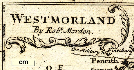
printed in scroll cartouche, upper left
WESTMORLAND / By Robt. Morden. |
|
| wxh, sheet:- | 21.5x33cm | |
| wxh, plate:- | 161x212mm | |
| wxh, map:- | 158x204mm | |
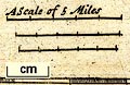
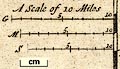
| inscription:- |
printed with scale lines
A Scale of 5 Miles |
|
| scale line:- | 5 miles = 27.6 mm | |
| scale line:- | 5 miles = 25.1 mm | |
| scale line:- | 5 miles = 23.5 mm | |
| scale:- | 1 to 320000 ? (1 to 316800 from average of scale lines assuming a statute mile) | |
| longitude, Kendal:- | 2d 26m W | |
|
||
|
||
| references:- |
: 1708: Fifty Six New and Accurate Maps of Great Britain,
Ireland and Wales: Nicholson, John & Sprint, John & Bell,
Andrew & Smith, Ralph : 1720=1731: Magna Britannia et Hibernia, Antiqua and Nova & New Survey of Great Britain: Nutt, M & Morphew, J (London) : 1731: Magna Britannia, Antiqua et Nova & Survey of England: Cox, Thomas (London) : 1738: Magna Britannia, Antiqua et Nova & New, Exact, and Comprehensive Survey Of The Ancient and Present State Of Great-Britain: Ward, Caesar & Chandler, Richard (London) |
|
| sources:- |
Chubb 1927 Hodson 1984 Armitt Library Wordsworth Trust Collection JandMN Collection Kendal Library Maps |
|
| items seen (illustrated items in bold):- | ||
|
|
Armitt Library : ALMC2008.14.9.1 -- map -- Westmorland | |
|
|
Dove Cottage : 2007.38.102 -- map -- Westmorland | |
|
|
Dove Cottage : 2007.38.103 -- map -- Westmorland | |
|
|
JandMN (106_2) -- map -- Westmorland | |
|
|
JandMN (107_1) -- map -- Cumberland | |
|
|
Kendal Library : Map 25 -- map -- Westmorland | |
|
|
Kendal Library : Map 40 -- map -- Westmorland | |