 Morden 1708

|

|
|
|
item:- JandMN (106_2) image:- © see bottom of page |
click to enlarge |
|
|
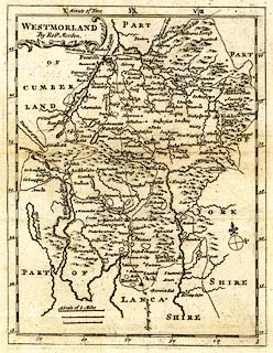
Map, uncoloured engraving, Westmorland, scale about 5
miles to 1 inch, by Robert Morden, 1690s, published 1701,
amended by Herman Moll, 1704, published by Thomas Cox, at
The Lamb, Royal Exchange, Cornhill, London, 1720-31?
Folded and tipped into Magna Britannia at the start of the county chapter. |
||

|
Morden 1708 | |
| map feature:- | scroll cartouche & compass rose & up is N (roughly) & scale lines & lat and long scales & sea plain & coast shaded & rivers & lakes & relief & hillocks & parks & county & settlements & roads | |
| inscription:- |
printed in scroll cartouche, upper left
WESTMORLAND / By Robt. Morden. |
|
| inscription:- |
printed with scale lines
A Scale of 5 Miles |
|
| scale line:- | 5 miles = 27.6 mm | |
| scale line:- | 5 miles = 25.1 mm | |
| scale line:- | 5 miles = 23.5 mm | |
| longitude, Kendal:- | 2d 26m W | |
| wxh, sheet:- | 21.5x33cm | |
| wxh, plate:- | 161x212mm | |
| wxh, map:- | 158x204mm | |
| scale:- | 1 to 320000 ? (1 to 316800 from average of scale lines assuming a statute mile) | |
|
|
notes | |