 Morden 1708

|

|
|

|
back to object record | |
| MAP FEATURES | ||
|
|
||
|
title
map maker |
Printed in a scroll cartouche, upper left of one sheet
is:-
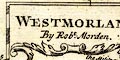
WESTMORLAND By Robt. Morden. on the other sheet in a wreath cartouche, lower right:- 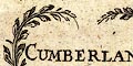
CUMBERLAND By Robt. Morden |
|
|
|
||
|
orientation
compass rose up is N |
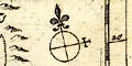
The Westmorland map has a compass rose printed right below centre; circle, lines for cardinal directions, North marked by a fleur de lys, East marked by a cross. Cumberland has a similar compass rose lower left. Each map is printed at the same orientation, with NbyE at the top of the sheet, roughly aligned with the meridians of longitude indicated by the scales in the map borders. |
|
|
|
||
|
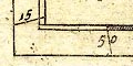
scale
scale lines |
Printed lower left on the Westmorland map are three
scales labelled:-
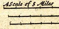
A Scale of 5 Miles The 5 miles = 27.6, 25.1 and 23.5 mm give an average map scale 1 to 316800 assuming a statute mile. The map scale is about:- 1 to 320000 5 miles to 1 inch Cumberland has three scale lines lower right. A Scale of 10 Miles The 10 miles = 37.1, 33.9 and 31.2 mm give an average map scale 1 to 472410 assuming a statute mile. The map scale is about:- 1 to 470000 7.5 miles to 1 inch |
|
|
|
||
| lat and long scales |
Printed in the map borders are scales of latitude and longitude for a slanted rectangular projection. Westmorland has the latitude scales chequered in minutes, labelled in 5 minute intervals; the bottom longitude scale is chequered in 5s labelled in 10s; the top longitude scale is labelled:- 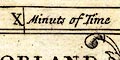
Minuts of Time divided and labelled in roman figures at minutes. Cumberland's latitude scale is chequered in 2s labelled in 10s; the bottom longitude scale is chequered in 3 minutes intervals, labelled at 15s; the top longitude scale is time, chequered in 20 seconds, labelled in roman figures at minutes. Be careful lining up top and bottom scales as the scale marks are not slanted correctly, keep in mind that 1d longitude is 4 minutes time. From the scales the longitude, Kendal = 2d 26m W This suggests a prime meridian 19 minutes West of Greenwich: unlikely? |
|
|
|
||
|
sea area
sea plain |
The sea areas is plain, labelled on the Cumberland
sheet:-
THE BRITISH OCEAN other sea areas, eg:- Solway Firth Itunae Bay Moricambo |
|
|
|
||
|
coast line
coast shaded foreshore headlands |
The coast line is emphasized by shading. On the Cumberland sheet some foreshore sands are outlined by a dotted line. One headland is noticed:- S. Bees Head |
|
|
|
||
|
rivers
bridges |
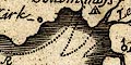
Rivers are drawn by a wiggly line tapering upstream. Some
rivers are labelled, eg:-
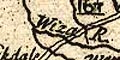
Wiza R Wampul Hunna R [Eden] Bridges are not always implied where a road crosses a stream. Some bridges might be marked by a double line crossing and interrupting a stream, separate from the slight road network, for example, west of Burneside. 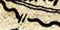
At the north of Thirlmere the double line symbol is drawn as well as the road it serves. 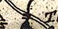
A few bridges are labelled, eg:- 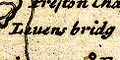
Levens bridg Burrow Bridg New Bridg [clearly marked at Newby Bridge] |
|
|
|
||
| lakes |
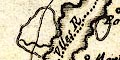
Lakes are drawn in outline, on the Westmorland map the shore is shaded, on Cumberland the whole area is shaded. As with many early maps the size and shapes of lakes and their connections with streams is not to be relied on. Some lakes are labelled:- Broadwater [Hawes Water] Brodwater [Ennerdale Water] Hawswater [Hayes Water] Thurlemire Ulles R [Ullswater] Wynandermere / Winander Mere Other lakes or tarns might be recognized, eg:- Bassenthwaite Lake Bleaberry Tarn [enlarged] Brothers water Burnmoor Tarn (?) Buttermere lake Coniston Water Crummock Water Derwent Water Devoke Water Easedale Tarn (?) Esthwaite Water Grasmere lake Kentmere Tarn Loweswater lake Rydal Water Wast Water The same lakes might be drawn a little differently on the two sheets; for example, see Grasmere and Rydal as two on Westmorland, but as one on Cumberland. |
|
|
|
||
|
relief
hillocks |
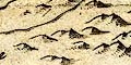
Relief is indicated by hillocks shaded to the east. These are clustered on the Westmorland sheet so that the Eden Valley is obvious between the Lakes and the Pennines, but the hills of the central Lakes are no bigger than those south of Kendal. Few hills are labelled, eg:- Knothill [Farleton Knot] Morvill Hill [Hugh Seat] In Cumberland there are very few hills; some are drawn larger and labelled, eg:- 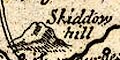
Skiddow hill Hardknot Wrynose but there is no hint of the central mountains. |
|
|
|
||
| beacons |
A hillock with a flag symbol, post and line, is
labelled:-
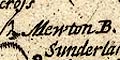
Mewton B. on Moota Hill. |
|
|
|
||
| forests |
Woodland is not indicated but some forests are labelled,
eg:-
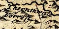
Thornthwate Forrest |
|
|
|
||
| parks |
Parks are drawn by a ring of fence palings, whose name
might be implied by a house name, eg:-
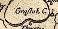
Grastock C. [Greystoke Castle in Greystoke Park] |
|
|
|
||
| county |
The county boundaries are a dotted line which is carried on alongside a boundary feature such as a river. Notice, on the Westmorland sheet, that the boundary runs through Ullswater as it does now (did till 1974) and puts the whole of Windermere in the county. Adjacent counties are labelled, eg:- PART OF CUMBERLAND on one sheet, and:- PART OF WESTMORLAND on the other. As well as other counties. Some topography is drawn outwith each county for continuity. |
|
|
|
||
|
wards
table of wards |
The Westmorland map does not show wards. On the
Cumberland sheet the ward boundaries are a dashed line, the
ward areas labelled by a letter which keys to a table
printed upper left:-
The Names of ye Divisions A. Cumberland B. North Allerdale C. South Allerdale D. Leath Ward E. Eshdale Ward |
|
|
|
||
| settlements |
Settlements are marked by a circle with added elements,
further differentiated by style of labelling.
|
|
| cities |
circle with buildings and tower and a cross; labelled in
upright block caps:-
CARLILE The settlement is cluttered by the engraving of roads, roman wall, rivers, but it is possible to two stars attached presumably indicating it sends two members to Parliament. The cross is presumably for the cathedral. |
|
| towns |
circle, buildings and tower; labelled in upright
lowercase text. eg:-
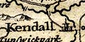
Kendall Appleby Penreth Cokermouth Cockermouth and Appleby have a star to indicate they each return one member to Parliament. |
|
|
villages
hamlets |
circle; labelled in italic lowercase text, eg:-
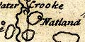
Natland Rosgill Strickland pa [Parva, Little] Langanby [Langwathby] Uldale A settlement might have a cross on the circle indicating an important church/abbey as at Seaton and Holme Coultram. |
|
| castles |
circle with a vestigial flag, a post with a line to the
side, eg:-
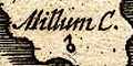
Millum C. The convention seems to work on Cumberland sheets but not Westmorland. |
|
|
|
||
| roads |
A few roads are drawn by double and single lines for more and less important routes The roads shown are more than just the John Ogilby routes used by early maps of Robert Morden. Some routes are labelled at the county boundary with their destination, eg:- to Dallerston Bridg to Carlile and there are some road names, eg:- Maiden Way the Military Way Also see:- MD13Twn.txt |
|
|
|
||
| miscellaneous | ||
|
|
||
|
mines
lead mines copper mines |
A label by the side of Derwent Water, south of Keswick,
is:-
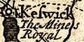
The Mines Royal who were based on one of the islands in the lake and had a smelter on the east side of the town. At Caldbeck are:- The Mines and in the fells north of Murton:- Lead Mine |
|
|
|
||
|
antiquities
battle sites tents |
A simple tent is drawn, labelled:-
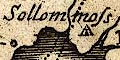
Sollom moss for the Battle of Solway Moss. |
|
|
|
||
|
antiquities
roman wall |
Hadrian's Wall is drawn as a crenellated wall from
Bowness-on-Solway through Carlisle, then NE and east into
Northumberland, labelled:-
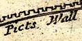
The Picts Wall |
|
|
|
||
|
antiquities
roman roads |
Drawn by a double line north from Kirkby Thore is:-
Maiden Way |
|
|
|
||
|
antiquities
roman forts |
A symbol NE of Ireby is labelled:-
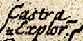
Castra Explor~ |
|
|
|
||
| stones |
Two small pillars on the county boundary are
labelled:-
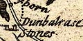
Dunbalrase Stones |
|
|
|
||
| crosses |
On the county boundary SE of Kirkby Stephen is:-
Holomil Cross On Stainmore:- Burgh Cross And Rear Cross is marked by a pointed pillar across the boundary, labelled just:- Rear |
|
Lakes Guides menu.