 Lakes in Cumberland

|

|
|
|
map type:- Lowes 1790s |
|
|
|
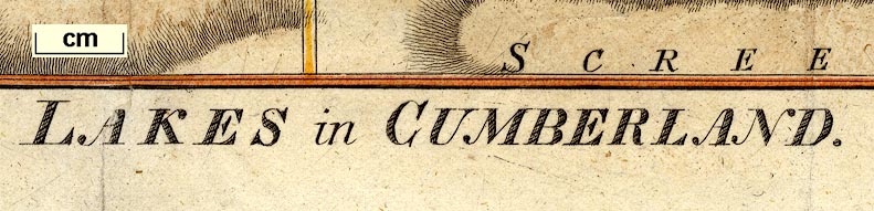
Maps, Lakes in Cumberland, 9 lakes on one sheet, engraved
by J Lowes, published by F Jollie, Carisle, Cumberland, and
C Law, Ave Maria Lane, London, 1790s.
The lakes are - Derwentwater, Bassenthwaite Lake, Buttermere Water, Crummock Water, Lowes Water, Ennerdale Water, Thurle Meer, Wast Water, and Devock Lake. Included in The History of the County of Cumberland by William Hutchinson, published by F Jollie, Carlisle, 1794. Included in A Descriptive Tour, and Guide to the Lakes, Caves, Mountains ..., by John Housman; published by F Jollie, Carlisle, 1800-21. |
||

|
Housman 1800 map 4 | |
|
(map example Dove Cottage : 2007.38.96)
|
||
| map feature:- | north point & rivers & lakes & relief & hill hachuring & woods & trees & settlements & roads | |
| inscription:- |
printed bottom, centre and right
LAKES in CUMBERLAND / J Lowes Sc. |
|
| wxh, sheet:- | 24.5x19.5cm | |
| wxh, map:- | 230x171mm | |
| sources:- |
Bicknell 1990 JandMN Collection Wordsworth Trust Collection Carlisle Library Maps Kendal Library Maps |
|
| items seen (illustrated items in bold):- | ||
|
|
Carlisle Library : Map 42 -- map -- Lakes in Cumberland | |
|
|
Dove Cottage : 2007.38.96 -- map -- Lakes in Cumberland | |
|
|
JandMN (233_4) -- map -- Lakes in Cumberland | |
|
|
Kendal Library : Map 39 -- map -- Lakes in Cumberland | |
|
|
Kendal Library (12_7) -- map -- Lakes in Cumberland | |