 Lowes 1790s

|

|
|
|
item:- JandMN (233_4) image:- © see bottom of page |
click to enlarge |
|
|
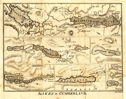
Map, uncoloured engraving, Lakes in Cumberland, engraved
by James Lowes, 1798 published by F Jollie, Carlisle,
Cumberland, 1800.
There are individual maps; Derwent Water and Bassenthwiate Water, Buttermere, Crummock Water and Lowes Water, Ennerdale Water, Thirlmere, Wast Water, and Devock Lake. Taken from a guide book, A Descriptive Tour, and Guide to the Lakes, Caves and Mountains, by John Housman, 1800, 5th edn 1812; previously published in William Hutchinson's History of the County of Cumberland, 1794. |
||

|
Lowes 1790s | |
| map feature:- | north point & rivers & lakes & relief & hill hachuring & woods & settlements & roads | |
| inscription:- |
printed bottom
LAKES in CUMBERLAND. |
|
| wxh, sheet:- | 27.5x22cm | |
| wxh, map:- | 232x171mm | |