 Land Utilisation Survey

|

|
|
|
map type:- Land Utilisation Survey 1932-35 |
|
|
|
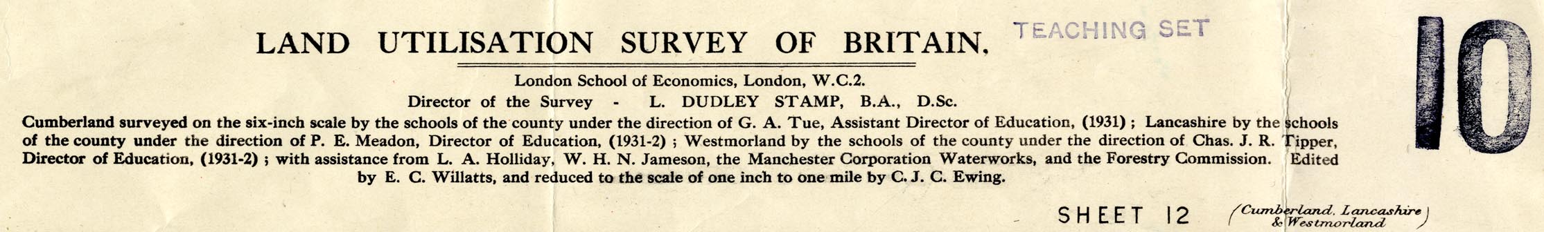
Map series, Land Utilisation Survey series, scale 1 inch
to 1 mile, by the Land Utilisation Survey of Britain,
directed by L Dudley Stamp, London School of Economics,
published by the Ordnance Survey, Southampton, Hampshire,
1932-35.
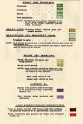
Maps are coloured in six classes of use - forest and woodland; meadowland and permanent pasture; arable or tilled land; heathland, moorland, commons and rough hill pasture; gardens, allotments, orchards and nurseries; and agriculturally unproductive land. The map sheets are arranged and numbered the same as the OS 1918 Popular Edition sheets. The sheets that concern Westmorland, Cumberland, and the parts of Lancashire north of the sands, and of Yorkshire, that became Cumbria are:- sheet 5 - Solway Firth and River Esk sheet 6 - Hexham sheet 8 - Workington and Cockermouth sheet 9 - Carlisle sheet 10 - Alston and Weardale sheet 12 - Keswick and Ambleside sheet 13 - Kirkby Stephen and Appleby sheet 18 - Wasdale sheet 19 - Windermere and Ulverston sheet 20 - Kirkby Lonsadle and Hawes sheet 24 - Lancaster and Barrow |
||
|
||
| references:- |
Stamp, L Dudley & Willats, E C: 1935: Land Utilisation
Survey of Britain: London School of Economics (London) |
|
| sources:- |
JandMN Collection |
|
| sources:- |
|
|
| items seen (illustrated items in bold):- | ||

|
JandMN (345) -- map (sheet 12) -- Keswick and Ambleside | |
|
|
JandMN (346) -- map (sheet 19) -- Windermere and Ulverston | |
|
|
JandMN (347) -- map (sheet 5) -- Solway Firth and River Esk | |