 Land Utilisation Survey 1932-35

|

|
|
|
item:- JandMN (345) image:- © see bottom of page |
click to enlarge |
|
|
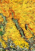
Map, colour lithograph, sheet 12, Keswick and Ambleside,
scale about 1 inch to 1 mile, surveyed by local schools,
plotted on an OS base map, directed by L Dudley Stamp,
published by the Land Utilisation Survey of Britain, London
School of Economics, London, 1933.
|
||

|
Land Utilisation Survey 1932-35 | |
| map feature:- | land utilisation | |
| inscription:- |
printed top centre
KESWICK & AMBLESIDE |
|
| inscription:- |
printed top right
LAND UTILISATION SURVEY OF BRITAIN. / London School of Economics, London, W.C.2. / Director of the Survey - L. DUDLEY STAMP B.A. D.Sc. / Cumberland surveyed by the schools of the county ... |
|
| wxh, sheet:- | 89x69cm | |
| wxh, map:- | 711x482mm | |
| scale:- | 1 to 63360 ? (nominal) | |