 Kitchin 1763

|

|
|
|
map type:- Kitchin 1763 |
|
|
|
Maps, Westmoreland, scale about 5.5 miles to 1 inch, and
Cumberland, scale about 8 miles to 1 inch, by Thomas
Kitchin, published by R and J Dodsley, Pall Mall, London,
1763-64.
Published in 'England Illustrated, Or, A Compendium Of The Natural History, Geography, Topography, And Antiquities Ecclesiastical and Civil, Of England and Wales. With Maps of the several Counties, And Engravings of many Remains of Antiquity, remarkable Buildings, and principal Towns. In Two Volumes. Vol.I. London: Printed for R. and J. Dodsley, in Pall-Mall, MDCCLXIV.' The maps are in vol.2; 1764, but released 1763. The descriptive texts for the counties include views of castles, abbeys, etc; the atlas has a map of England and Wales and the roads 'with the distances by the Mile-Stones'; its size is 8 1/2 x 11 1/4 ins. The whole work was reviewed in The Monthly Review or Literary Journal, 1764 - 'The author of the work before us, does not profess to accumulate new materials, but only to raise the best structure he can with the old; and as the accounts hitherto published of England and Wales, are thrown together, he says, with unaccountable disorder and confusion, he has undertaken to regulate this chaos ... the maps, (which are executed with a good share of elegance and neatness) in their proper places ... In the introduction, page 1, we are informed ... that ... the first meridian has been generally supposed to pass [through Tenerife]. But notwithstanding this method of computation ... in all the maps the longitude is (more properly) expressed east and west from London: and in Vol.II. page 3, it is expressly stated, that London 'is the meridian from which all British Geographers compute the measures of longitude.' ... Published in 'Kitchin's English Atlas; Or, A Compleat Set of Maps Of All The Counties of England and Wales, Containing all the Cities, Towns, Parishes, Rivers, Roads, Seats, and, in General, every other Particular that is usually sought for, or to be found, in Maps. The Whole engraved in the neatest and most accurate Manner, from Drawings after actual Surveys and other the best Authorities. By Thomas Kitchin, Geographer to his Royal Highness the Duke of York. London. Printed for J. Dodsley, in Pall-Mall,' 1765. |
||
|
(exampe map Armitt Library : ALMC2008.26.1)
|
||
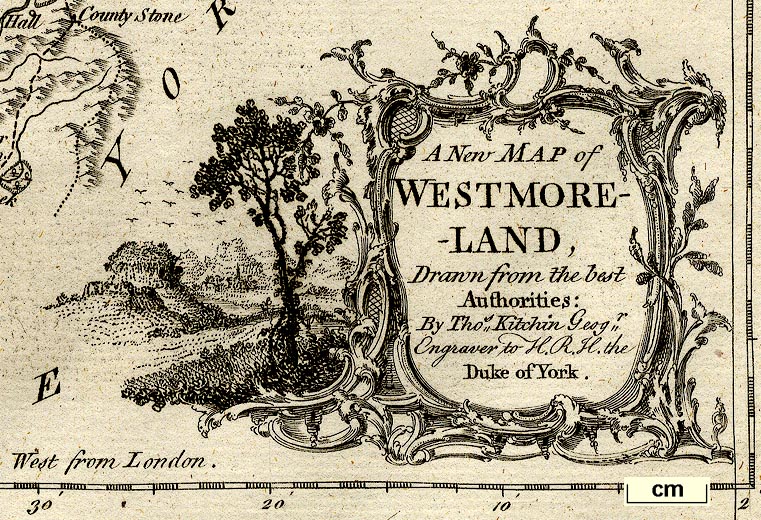
| map feature:- | baroque cartouche & table of symbols & compass rose & up is N & scale line & lat and long scales & lat and long grid (just) & sea plain & coast shaded & rivers & lakes & relief & hill hachuring & woods & forests & parks & county & settlements & roads | |
| inscription:- |
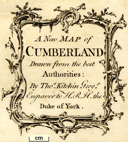
printed title cartouche, lower right
A New Map of / WESTMORE- / -LAND, / Drawn from the best / Authorities : / By Thos. Kitchin Geogr. / Engraver to H.R.H. the / Duke of York. |
|
| wxh, sheet:- | 28x22cm | |
| wxh, plate:- | 263x201mm | |
| wxh, map:- | 256x194mm | |
| inscription:- |
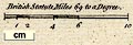
printed above scale line
British Statute Miles 69 to a Degree. |
|
| scale line:- | 10 miles = 42.3 mm | |
| scale:- | 1 to 380000 ? (1 to 380460 from scale line) | |
| longitude, Kendal:- | 2d 50.9m W | |
|
||
|
||
| references:- |
: 1763 (1764): England Illustrated & Compendium of the
Natural History, Geography, Topography, and Antiquities
Ecclesiastical and Civil, of England and Wales: Dodsley, R
and J (London) Kitchin, Thomas: 1765: Kitchin's English Atlas: Dodsley, J (London) : 1764: Monthly Review & Literary Journal: 30: pp.262-66 |
|
| sources:- |
Chubb 1927 (CCXXIV) Hodson 1984 JandMN Collection Wordsworth Trust Collection Armitt Library Kendal Library Maps |
|
| items seen (illustrated items in bold):- | ||

|
Armitt Library : ALMC2008.14.26.1 -- map -- New Map of Westmoreland | |
|
|
Dove Cottage : 2007.38.106 -- map -- New Map of Westmoreland | |
|
|
Dove Cottage : 2007.38.107 -- map -- New Map of Westmoreland | |
|
|
Hampshire Museums : FA1997.115 -- road map -- Map of all the Direct, and the Principal Cross Roads, in England and Wales | |
|
|
JandMN (120_1) -- map -- New Map of Westmoreland | |
|
|
JandMN (375) -- map -- New Map of Cumberland | |
|
|
Kendal Library : Map 32 -- map -- New Map of Westmoreland | |
|
|
Kendal Library : Map 33 -- map -- New Map of Westmoreland | |