 Kitchin 1763

|

|
|
|
item:- Hampshire Museums : FA1997.115 image:- © see bottom of page |
click to enlarge |
|
|
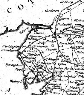
Road map, uncoloured engraving, Map of all the Direct,
and the Principal Cross Roads, in England and Wales, scale
about 30 miles to 1 inch, by Thomas Kitchin, published about
1763-64.
Direct and cross roads over the whole country, with road distances; a similar selection to Ogilby's roads. |
||

|
Kitchin 1763 | |
| map feature:- | pictorial cartouche & compass rose & up is N & county & table of counties & settlements & roads & road distances | |
| inscription:- |
printed cartouche
A / New most / Accurate & Complete / MAP / of all the Direct, and the / Principal Cross ROADS, in / ENGLAND, / and / WALES, / Carefully corrected from / Late Surveys : / with the Distances by the / Mile Stones, / and other most exact / Admensurations between / Town and Town. landscape and trees, with a post chaise and a milestone |
|
| wxh, sheet:- | 47x39cm | |
| wxh, plate:- | 361x359mm | |
| wxh, map:- | 349x346mm | |
| scale:- | 1 to 1900000 ? (1 to 1913187 from London to Bristol distance) | |
|
|
notes | |