 Kitchin 1763

|

|
|

|
back to object record | |
| NOTES KITCHIN'S ROAD MAP of ENGLAND AND WALES, 1760s | ||
|
These notes are taken from a map of England and Wales by
Thomas Kitchin, published about 1760s. The map is in the Map
Collection of Hampshire CC Museums Service, item FA1997.115.
The notes are biased twoards a Westmorland and Cumberland
interest.
|
||
|
The map size is about wxh, sheet=47x39cm, plate 361x359mm,
map 349x346mm.
|
||
|
Notes about the Dodsley map, 1763-64, are taken from an
example in Ross Old Books and Maps, with thanks.
|
||
| Identification | ||
|
The map is like the map by Kitchin published volume 2 of:-
|
||
|
England Illustrated, Or, A Compendium Of The Natural
History, Geography, Topography, And Antiquities
Ecclesiastical and Civil, Of England and Wales. With Maps of
the several Counties, ... Printed for R. and J. Dodsley, in
Pall-Mall. MDCCLXIV.
|
||
|
Which Dodsley announced late 1763. In that atlas the
frontispiece to volume 2 has the title:-
|
||
|
KITCHIN'S most ACCURATE MAP of the ROADS of ENGLAND and
WALES, with the Distances by the Mile-Stones, and other most
exact Admensurations between Town & Town.
|
||
|
in a scroll cartouche decorated with trees, and a harbour
with a ship to the left, and ?turnips, sack, flail, and
wheatsheaf below. Printed at the top is:-
|
||
|
Frontispiece Vol.II.
|
||
|
and at the bottom:-
|
||
|
Printed for R. and I. Dodsley in Pall-Mall.
|
||
|
The example road in the explanation below the title, and the
cartouche of county names and numbers, are identical to the
item in the Map Collection which is thought to be a later
edition. The title cartouche is different though with some
of the same wording.
|
||
|
The map has been seen in a map shop ascribed to Walpoole,
1794, presumably the 1794 edition of The New and Complete
English Traveller, published by Alexander Hogg, earlier
published as the New British Traveller, 1784.
|
||
| MAP FEATURES | ||
|
|
||
|
title cartouche
pictorial cartouche map maker |
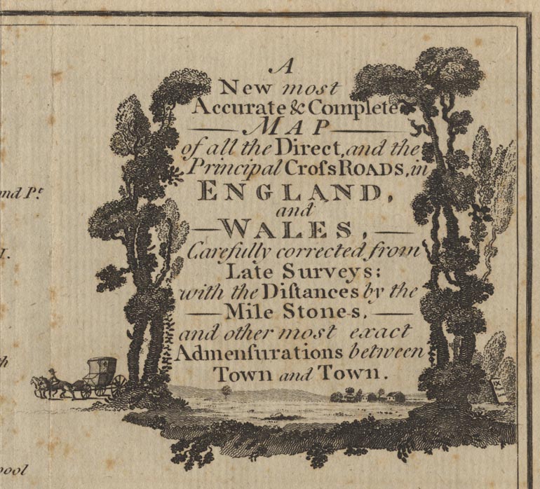
Printed upper right is a title text set in landscape with a grove of trees, a post chaise to the right, a milestone:- IX From London to the right. The title is:- A New most Accurate & Complete MAP of all the Direct, and Principal Cross ROADS, in ENGLAND and WALES, Carefully corrected from Late Surveys: with the Distances by the Mile Stones, and other most exact Admensurations between Town and Town. The maps shows England Wales; plus parts of Scotland, Ireland and France in outline, with a few border or coastal places. No where on the map is any note of the map maker's or engraver's names. The style of the map is late 18th century. |
|
|
|
||
|
orientation
compass rose up is N |
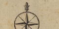
Printed lower left is a simple compass rose; star points for the cardinal directions, lines for the half cardinal directions, North marked by a fleur de lys. The map is printed with North at the top. |
|
|
|
||
| scale |
The map has no indication of scale. It is possible to
estimate a scale form the size of the map, positions of
towns, etc. The map distance from London to Bristol is 91 mm
for 174.1 Km, giving a scale roughly:-
1 to 1900000 30 miles to 1 inch |
|
|
|
||
|
table of symbols
road distances |
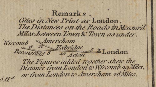
Printed upper right under the title is:- Remarks Cities in New Print as London, 'new' appears to mean upright rather than italic, and:- The Distances on the Roads in Measur'd Miles, between Town and Town as under. [diagram of a part road with places and distance figures] The figures added together shew the Distances from London to Wicomb 29 Miles, or from London to Amersham 26 Miles. |
|
|
|
||
|
sea area
sea plain |
The sea is plain; some sea areas are labelled, eg:-
THE IRISH SEA Solway Firth |
|
|
|
||
|
coast line
coast shaded |
The coast line is shaded for emphasis. |
|
|
|
||
| rivers |
Except for the larger river estuaries:-
Thames River big enough to be labelled, rivers are not shown on the map. Short lengths of the River Eden and River Derwent are drawn by a tapering wiggly line. |
|
|
|
||
| country |
England and Wales are not separated by anything except
the county boundaries, and are not labelled. The scottish
border is a dashed line. Neighbouring countries are
labelled, eg:-
SCOTLAND |
|
|
|
||
|
county
table of counties |
County boundaries are a dashed line. The county areas are labelled with a number, keying to a table, numbering from the north:- REFERENCES TO THE COUNTIES 1 Northumberland 2 Cumberland 3 Durham 4 Westmorland 5 Lancashire ... in a scroll cartouche. |
|
|
|
||
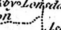
| settlements |
Settlements are marked by a circle perhaps with added
elements, differentiated by style of labelling.
|
|
| city |
circle and towers; labelled in upright lowercase text,
eg:-
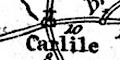
Carlile |
|
|
town
village |
circle; labelled in italic lowercase text, eg:-
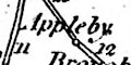
Appleby |
|
|
There are other places as well, some quite small,
necessary as nodes in the road network.
|
||
|
|
||
|
roads
road distances |
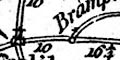
The map has a network of roads drawn by a double line. At this scale only major routes are shown. Road distances are marked in figures beside the road between towns or villages. Whole miles or half and quarters are given, eg:- 12 8 3/4 The routes across Westmorland, Cumberland etc are:- from the south trhough Lancaster, 6 1/2 to Carnforth, Lancashire; 5 to Burton, 12 to Kendal, 16 to Shap, Westmorland; 11 to Penrith, 10 1/2 to Heskit, 8 to Carlile, Cumberland. from Kendal, 13 to Ambleside, Westmorland; 10 3/4 to Thirlspot, 5 1/2 to Keswick, 15 1/2 to Cockermourh, Cumberland. from Egremont, 14 to Cockermouth, 7 to Bolton, pass near Wigton, 18 to Carlile, Cumberland. from Lancaster, across Lancashire Sands, 17 to Cartmel, 13 to Hawkshead, Lancashire; 18 1/2 to Whitehaven, Cujmberland. from Lancaster, across Lancaster Sands and Ulverston Sands, 18 to Ulverstone, Lancashire; 16 to Ravenglass, pass near Egremont, to Wihtehaven, Cumberland. from Carlile, 10 to Brakenhill, pass near Longtown, Cumberland; 14 1/2 to Castleton, and on through Scotland; to Berwick, Northumberland. from the east through Haltwessel, Northumberland; 16 1/4 to Brampton, 10 to Carlile, Cumberland. from the east through Enilstone, Northumberland; to Brampton, Cumberland. from the south east through Bowes, Yorkshire; 13 to Brough, 12 to Appleby, Westmorland; 20 to Penrith, Cumberland. |
|
Lakes Guides menu.