 Kitchin 1763

|

|
|
|
item:- JandMN (375) image:- © see bottom of page |
click to enlarge |
|
|
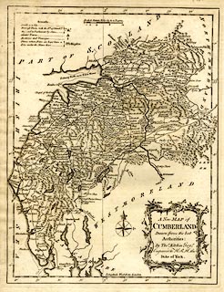
Map, uncoloured engraving, A New Map of Cumberland, scale
about 8.5 miles to 1 inch, by Thomas Kitchin, 1763.
Included in England Illustrated. |
||

|
Kitchin 1763 | |
| map feature:- | baroque cartouche & table of symbols & compass rose & up is N & scale line & lat and long scales & lat and long grid (just) & sea plain & coast shaded & rivers & lakes & relief & hill hachuring & woods & forests & parks & county & settlements & roads | |
| inscription:- |
printed title cartouche, lower right
A New MAP of / CUMBERLAND / Drawn from the best / Authorities : / By Thos. Kitchin Geogr. / Engraver to H.R.H. the / Duke of York. |
|
| inscription:- |
printed above scale line
British Statute Miles 69 to a Degree. |
|
| scale line:- | 12 miles = 35.8 mm | |
| scale:- | 1 to 540000 ? (1 to 539445 from scale line) | |
| wxh, sheet:- | 21.5x28cm | |
| wxh, plate:- | 202x260mm | |
| wxh, map:- | 195x254mm | |