 Geological Map of the English Lake District

|

|
|
|
map type:- Jenkinson 1875 map 2 |
|
|
|
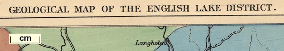
Geological Map of the English Lake District, Westmorland,
Cumberland and Lancashire, now Cumbria, scale about 11.5
miles to 1 inch, published by Edward Stanford, Stanford's
Geographical Establishment, 55 Charing Cross, London, before
1875.
Published in A Practical Guide to the English Lake District, by Henry Irwin Jenkinson, published by Edward Stanford, 55 Charing Cross, London, 4th edn 1875. Published, probably, in the 6th edn 1879. Published, probably, in the 8th edn 1885. |
||
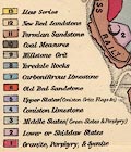
| map feature:- | up is N & scale line & sea plain & coast line & rivers & county & settlements & railways & canals & geology & stratigraphical column | |
| inscription:- |
printed top
GEOLOGICAL MAP OF THE ENGLISH LAKE DISTRICT |
|
| inscription:- |
printed bottom right
Stanford's Geographical Establishment |
|
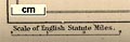
| wxh, map:- | 122x190mm | |
| scale line:- | 15 miles = 33.2 mm | |
| scale:- | 1 to 730000 ? (1 to 727113 from scale line) | |
|
||
|
||
| sources:- |
JandMN Collection Bicknell 1990 |
|
| items seen (illustrated items in bold):- | ||

|
JandMN (28_2) -- geological map -- Geological Map of the English Lake District | |