 Jenkinson 1875 map 2

|

|
|
|
item:- JandMN (28_2) image:- © see bottom of page |
click to enlarge |
|
|
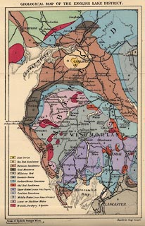
Geological Map of the English Lake District, Westmorland,
Cumberland and Lancashire, colour printed, scale about 11.5
miles to 1 inch, by Stanford's Geographical Establishment,
published by Edward Stanford, 55 Charing Cross, London,
1875.
Tipped in opposite page xli of A Practical Guide to the English Lake District, by Henry Irwin Jenkinson, 4th edition 1875. |
||

|
Jenkinson 1875 map 2 | |
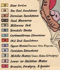
| map feature:- | up is N & scale line & sea plain & coast line & rivers & county & settlements & railways & canals & geology & stratigraphical column | |
| inscription:- |
printed top
GEOLOGICAL MAP OF THE ENGLISH LAKE DISTRICT |
|
| inscription:- |
printed bottom right
Stanford's Geographical Establishment |
|
| scale line:- | 15 miles = 33.2 mm | |
| scale:- | 1 to 730000 ? (1 to 727113 from scale line) | |
| wxh, map:- | 122x190mm | |
|
||