 Hutchinson 1748

|

|
|
|
map type:- Hutchinson 1748 |
|
|
|
Maps, Correct Map of Westmorland, scale about 7 miles to
1 inch, and of Cumberland? possibly by Thomas Hutchinson,
published by T Osborne et al, 1748; published 1748-50.
Published in 'GEOGRAPHIA Magnae Britanniae. Or, CORRECT MAPS of all the COUNTIES in ENGLAND, SCOTLAND, and WALES; with General Ones of both KINGDOMS, and of the several Adjacent Islands: Each MAP expressing the CITIES, BOROUGHS, Market and Presbytery Towns, Villages, Roads and Rivers; with the No. of Members sent to Parliament; together with Tables of the high and cross Roads, market days, &c. / Printed for S. Birt. I. Osborne. T. Osborne. A. Millar. D. Browne. I. Robinson. I. Hodges. ... Published according to Act of Parliament October 12th. 1748.' The atlas title page is engraved by Wale; the atlas size is 4 x 7 ins; Hampshire is plate 14; two maps in the atlas are signed by Hutchinson, others are similar in style, all by the same hand; the maps follow Morden 1695 with little attempt to use later sources. The tables of roads include 158 routes. The atlas's publishers also owned, in part, Defoe's 'Tour' and they associated the two works - 'Now Engraving, In a beautiful Manner, and of a proper Size to carry in the Pocket, or to bind with the Tour thro, the whole Island of Great Britain, A Complete Set of Maps of all the Counties of England, Scotland, and Wales ...' in an advert in the London Evening Post, July 1747. Published in another edition '... Printed for: T, Osborne, D, Browne, J. Hodges, A. Miller, J. Robinson, W Johnston, P. Davey & B. Law. ... 1748.' published about 1756 |
||
|
(map example Dove Cottage : 2007.38.73)
|
||
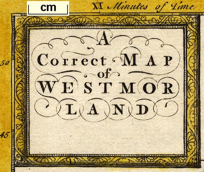
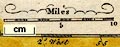
| map feature:- | picture frame cartouche & compass rose & up is N (about 17d E of N) & scale line & lat and long scales & sea plain & coast form lines & rivers & lakes & relief & hillocks & woods & trees & forests & parks & county & settlements | |
| inscription:- |
printed title cartouche, upper left
A / Correct MAP / of / WESTMOR / LAND |
|
| wxh, sheet:- | 19x17cm | |
| wxh, map:- | 171x146mm | |
| scale line:- | 10 miles = 36.8 mm | |
| scale:- | 1 to 440000 ? (1 to 437322 from scale line wrongly assuming a statute mile) | |
|
||
| references:- |
: 1748: Geographia Magnae Britanniae & Correct Maps of all
the Counties in England, Scotland, and Wales: Birt, S &
Osborne, T & Browne, D & Hodges, J & Osborne, J & Millar, S
& Robinson, J & Johnston, W & Davey, P & Law, B (London) : 1750: Geographia Magnae Britanniae & Correct Maps of all the Counties in England, Scotland, and Wales: Birt, S & Osborne, T & Hodges, J & Osborne, J & Millar, A & Robinson, J (London) |
|
| sources:- |
Chubb 1927 (CLXXXIX) Hodson 1984 Fordham 1924 Wordsworth Trust Collection Armitt Library |
|
| items seen (illustrated items in bold):- | ||

|
Armitt Library : ALMC2008.14.16 -- map -- Correct Map of Westmorland | |
|
|
Carlisle Library : Map 167 -- map -- Correct Map of Westmorland | |
|
|
Dove Cottage : 2007.38.73 -- map -- Correct Map of Westmorland | |
|
|
Dove Cottage : 2007.38.74 -- map -- Correct Map of Westmorland | |