 Hutchinson 1748

|

|
|
|
item:- Dove Cottage : 2007.38.73 image:- © see bottom of page |
click to enlarge |
|
|
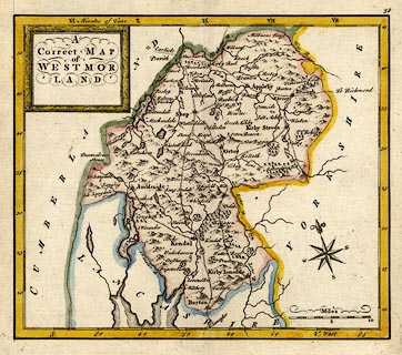
Map, hand coloured engraving, A Correct Map of
Westmorland, scale about 7 miles to 1 inch, possibly by
Thomas Hutchinson, published by T Osborne et al, 1748.
Plate 38 from Geographia Magnae Britanniae, or, Correct Maps of all the Counties in England, Scotland, and Wales, printed for S Birt, I Osborne, T Osborne, A Millar, D Browne, I Robinson, and I Hodges, 1748. |
||

|
Hutchinson 1748 | |
| map feature:- | picture frame cartouche & compass rose & up is N (about 17d E of N) & scale line & lat and long scales (slanted rectangular projection) & time from London & sea plain & coast form lines & rivers & lakes & relief & hillocks & woods & forests & parks & county & settlements & roads | |
| inscription:- |
printed title cartouche, upper left
A / Correct MAP / of / WESTMOR / LAND |
|
| scale line:- | 10 miles = 36.8 mm | |
| scale:- | 1 to 440000 ? (1 to 437322 from scale line wrongly assuming a statute mile) | |
| wxh, sheet:- | 19x17cm | |
| wxh, map:- | 171x146mm | |
|
|
notes | |