 Hutchinson 1748

|

|
|

|
back to object record | |
| MAP FEATURES | ||
|
|
||
|
title cartouche
picture frame cartouche |
Printed in a picture frame cartouche, upper left:-
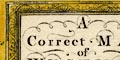
A Correct MAP of WESTMORLAND Top right is the plate number, 38. |
|
|
|
||
|
orientation
compass rose up is N |
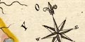
Printed lower right is a compass rose; no circle, star points for the cardinal and half cardinal directions, North marked by a spear point fleur de lys, E, S and W points labelled by letter. The map is printed with N by E at the top of the sheet. |
|
|
|
||
|
scale line
scale |
Printed lower right is a scale of:-
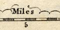
Miles chequered in miles, labelled at 5 and 10. The 10 miles = 36.8 mm gives a scale 1 to 437322 wrongly assuming a statute mile. The map scale is about:- 1 to 440000 7 miles to 1 inch |
|
|
|
||
|
lat and long scales
hours from London |
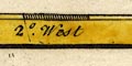
Printed in the map borders, tinted yellow, are scale of latitude and longitude for a slanted rectangular projection; chequered at 5 minutes intervals, labelled at 10s. The longitude scale is labelled West by the 2 degree mark. Reading from the scales the latitude, Kendal = 2d 25m W which implies a prime meridian about 20 minutes W of Greenwich, some way west of central London. However the whole map seems to be compressed E-W and these deductions are unreliable. The map includes from about 1d 40m to 2d 50m W, from 54d 5m to 54d 45m N; the whole of Westmorland. Note that the 50m mark in the lower longitude scale is labelled 55. |
|
|
|
||
|
sea area
sea plain |
What little sea area is shown is plain.
|
|
|
|
||
|
coast line
coast form lines foreshore |
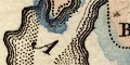
The coast line in the Leven and Kent Estuaries is emphasized by form lines. Foreshore sands are marked as dotted areas. |
|
|
|
||
|
rivers
bridges |
Rivers are draw by wiggly line tapering upstream. Some
rivers are labelled, eg:-
Blenkern R. Ken R. Eamont R. Bridges are implied where a road crosses and interrupts a stream. At least on is labelled:- 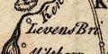
Levens Bri. which doesn't have a road and isn't marked. |
|
|
|
||
| lakes |
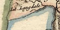
Lakes are drawn by an outline with form lines or shaded
shores. Some lakes are labelled:-
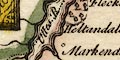
Ulles R. [W]inander Meer Some islands are drawn in Windermere. Other lakes might be recognized:- Angle Tarn (?) Blelham Tarn Brothers Water Coniston Water Easedale Tarn Grasmere Hawes Water Hayes Water (?) Kentmere Tarn Rydal Water |
|
|
|
||
|
relief
hillocks |
Relief is indicated by knobbly hillocks. These are
clustered to suggest the central Lakes mountains and the
Pennines. Some hillocks are larger, and some are labelled,
eg:-
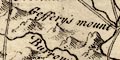
Geffery's Mount Whinfield Hill |
|
|
|
||
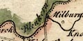
|
woods
trees forests |
Small tree symbols indicate some woodland. These might be
grouped, as near Killington, and might be labelled, eg:-
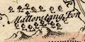
Mallerstang For A forest are might not have tree symbols, as:- Milburne Forest |
|
|
|
||
| parks |
Parks are shown by a ring of fence palings enclosing
woodland. At least one is labelled:-
Brigster Park |
|
|
|
||
| county |
County boundaries are a fine dotted line, continued alongside a boundary feature, tinted on the inner side for each county; Westmorland pink with a pale wash over the whole county area, Yorkshire yellow, Lancashire blue, Cumberland green. The adjacent counties are labelled, eg:- CUMBERLAND Windermer is correctly included in the county; the boundary leaves Ulswater to far south. very little is shown outwith the county. |
|
|
|
||
| settlements |
Settlements are marked by a circle with added elements,
buildings etc, and differentiated by style of labelling.
|
|
| towns |
circle, buildings, towers; labelled in uptight lowercase
text, eg:-
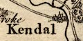
Kendal Orton Kendal has a few more buildings. |
|
|
villages
hamlets |
circle; labelled in italic lowercase text, eg:-
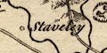
Staveley Underbarrow Oddledon |
|
|
|
||
| roads |
A network of more important roads is drawn by double lines. This includes the Lancaster Carlisle route through Burton, Kendal, Shap and Penrith. The Kendal to Keswick routes stops at Ambleside, but a route from Ambleside over Kirkstone Pass? close to the head of Hawes Water, to Patterdale, is shown, with a branch through the hills to join the Lancaster Carlisle road south of Shap. And so on. Destinations of some of the roads are given at the county boundary, eg:- to Lancaster to Carlisle |
|
|
|
||
| miscellaneous | ||
|
|
||
| beacons |
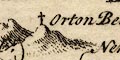
A cross (+) is drawn on a hillock NE of Orton, labelled:- Orton Beacon |
|
|
|
||
|
stones
antiquities |
A circle at the road junction south of Shap is
labelled:-
Stone Heaps Some indeterminate marks on the boundary with Cumberland are labelled:- 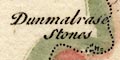
Dunmalrase Stones |
|
Lakes Guides menu.