 Westmoreland

|

|
|
|
map type:- Gibson 1759 |
|
|
|
Maps, Westmoreland, scale about 10.5 miles to 1 inch, and
Cumberland? by John Gibson, published by J Newberry, St
Paul's Churchyard, London, 1759; published 1759-1779.
Published in 'New and Accurate MAPS of the Counties of England and Wales Drawn from the latest Surveys By J. Gibson. London Printed for J. Newberry at the Bible and Sun in St. Pauls Church Yard', 1759. The atlas size is 2 1/2 x 4 3/8 ins; the title page has an 'Explanation of the characters in the Maps'; the map is plain on the reverse, it has plate no 38 top right. An advertisement in Lloyd's Evening Post, May 22-24, 1759 states 'This day were publish'd in a Neat Pocket Volume, Price 4s, bound in Calf, 5s 6d with maps colour'd New and Accurate Maps of the Counties of England ...' A notice in the Public Advertiser suggest the atlas may have been aimed at children, it is listed with twelve 'useful and pretty Books' for 'the little Gentlemen and Ladies of the Kingdoms' available from 'their old Friend, Mr. Newberry.' Published in an edition '... London. Printed for T. Carnan, in St. Paul's Church Yard ...', 1770. Published in an edition '... London. Printed for T. Carnan & F. Newberry, jr. 1779'. |
||
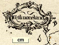
| map feature:- | baroque cartouche & north point & up is N & scale line & lat and long scales (rectangular projection, W from London) & coast form lines & rivers & lakes & relief & hillocks & beacons & county & settlements & roads (few) & descriptive text | |
| inscription:- |
printed title cartouche, upper left
Westmoreland |
|
| wxh, sheet:- | 13x8.5cm | |
| wxh, map:- | 112x63mm | |
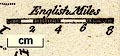
| inscription:- |
printed above scale line
English Miles |
|
| scale line:- | 8 miles = 20.4 mm | |
| scale:- | 1 to 630000 ? (1 to 631115 from scale line wrongly assuming a statute mile) | |
| longitude, Kendal:- | 2d 50m W | |
| scale:- | 1 to 680000 ? (1 to 675840 from scale line assuming a statute mile) | |
| scale line:- | 8 miles = 3/4 ins | |
|
||
| references:- |
Gibson, J: 1759: New and Accurate Maps of the Counties of
England and Wales: Newberry, J (London) Gibson, J: 1779: New and Accurate Maps of the Counties of England and Wales: Carnan, T (London) |
|
| sources:- |
Chubb 1927 (CCXIII) Hodson 1984 Armitt Library |
|
| items seen (illustrated items in bold):- | ||

|
Armitt Library : ALMC2008.14.119 -- map -- Westmoreland | |