 Gibson 1759

|

|
|
|
item:- Armitt Library : ALMC2008.14.119 image:- © see bottom of page |
click to enlarge |
|
|
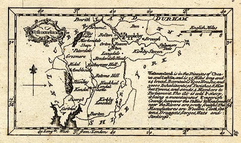
Map, uncoloured engraving, Westmoreland ie Westmorland,
scale 10 miles to 1 inch, by John Gibson, published by J
Newbery, at the Bible and Sun, St Paul's Churchyard, London,
1759.
Plate 38 from New and Accurate Maps of the Counties of England and Wales. Despite its late date the map has only two roads: the Lancaster to Carlisle road through Burton, Kendal, Shap, Westmorland, to Penrith, Cumberland; and the road from Kendal to Keswick through Ambleside, Westmorland. These are the two routes described by John Ogilby 1675. The descriptive text on the map is:- 'Westmoreland is in the Dioceses of Chester and Carlisle, and is 35 Miles long and 24 broad. It contains 6500 Houses, and 30000 Inhabitants, 26 Parishes, 8 Market-Towns, and sends 4 Members to Parliament. The Air is cold & sharp. it being a mountainous and moorish County; however the Vallies and Meadows near the Rivers are pretty fruitful. The Manufactures are Woollen Cloth, Cottons, Druggets, Serges, Hats and Stockings.' |
||

|
Gibson 1759 | |
| map feature:- | baroque cartouche & north point & up is N & scale line & lat and long scales (rectangular projection, W from London) & coast form lines & rivers & lakes & relief & hillocks & beacons & county & settlements & roads (few) & descriptive text | |
| inscription:- |
printed title cartouche, upper left
Westmoreland |
|
| inscription:- |
printed above scale line
English Miles |
|
| scale line:- | 8 miles = 20.4 mm | |
| longitude, Kendal:- | 2d 50m W | |
| wxh, sheet:- | 13x8.5cm | |
| wxh, map:- | 112x63mm | |
| scale:- | 1 to 630000 ? (1 to 631115 from scale line wrongly assuming a statute mile) | |
|
|
notes | |