 Gibson 1759

|

|
|

|
back to object record | |
| MAP FEATURES | ||
|
|
||
|
title
map maker |
Printed upper left in a baroque cartouche:-
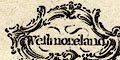
Westmoreland |
|
|
|
||
|
descriptive text
population, Westmorland Westmorland, extent electoral data |
Printed lower right is a description of the county:-
Westmoreland is in the Dioceses of Chester and Carlisle, and is 35 Miles long and 24 broad. It contains 6500 Houses, and 30000 Inhabitants, 26 Parishes, 8 Market-Towns, and sends 4 Members to Parliament. The Air is cold & sharp. it being a mountainous and moorish County; however the Vallies and Meadows near the Rivers are pretty fruitful. The Manufactures are Woollen Cloth, Cottons, Druggets, Serges, Hats and Stockings. |
|
|
|
||
|
orientation
north point up is N |
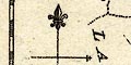
Printed on the left is a north point; N-S line, E-W cross line, North marked by a fleur de lys, East marked by a patriarchal cross. The map is printed with North at the top of the sheet. |
|
|
|
||
|
scale
scale line |
Printed upper right is a scale of:-
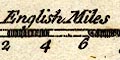
English Miles chequered and labelled in miles. The 8 miles = 20.4 mm gives a map scale 1 to 631115 assuming a statute mile. The map scale is about:- 1 to 630000 10 miles to 1 inch |
|
|
|
||
| lat and long scales |
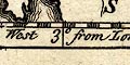
Printed in the map borders are scales of latitude and longitude for a rectangular projection; chequered in 2 minute intervals, labelled at 10s. The bottom longitude scale is labelled:- Longde. West from London Reading from the scales the longitude, Kendal = 2d 52m W suggesting a prime meridian 4m E of Greenwich, which is unlikely. |
|
|
|
||
|
sea area
sea plain |
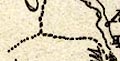
The tiny amount of sea area shown in the Leven and Kent
Estuaries is plain.
|
|
|
|
||
|
coast line
coast form lines |
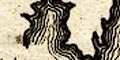
The coast line is emphasized by form lines. |
|
|
|
||
|
rivers
bridges |
Rivers are drawn by a wiggly line tapering upstream. A few rivers are labelled, eg:- Lone R. Hunna R [Eden] The second example is a nice instance of what can go wrong when copying: an old name for the Eden is the Ituna; the It has become an H. Some of the few roads cross streams, but as they are engraved by a single line northing is indicated about bridges. |
|
|
|
||
| lakes |
A couple of lakes are drawn by an outline with form
lines. Each is labelled:-
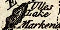
Ulles Lake Winander Meer |
|
|
|
||
|
relief
hillocks |
Just two small hillocks are used to indicate relief. One
to support Orton Beacon; the other labelled:-
Betone Hill on the road north of Kendal - which has far greater hills to climb in the county further north. |
|
|
|
||
| county |
The county boundary is a dotted line which is carried on alongside a boundary feature. All Windermere and part of Ullswater are included in the county, roughly as they should be. Adjacent counties are divided by a finer dotted line, and are labelled, eg:- CUMBERLAND |
|
|
|
||
| settlements |
Settlements are marked by a circle with added elements,
perhaps differentiated by style of labelling.
|
|
|
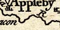
towns
electoral data distances from London |
circle, small buildings; labelled in italic lowercase
text, eg:-
Kendal Kirkby Steven except:- 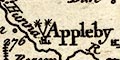
Appleby / 276 in upright lowercase text, being the de jure county town. It has two stars attached for the two members it sends to Parliament; the number is the distance from London. |
|
|
villages
hamlets |
circle; labelled in italic lowercase text, eg:-
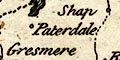
Paterdale Ridal |
|
|
|
||
| roads |
Roads are drawn by a single line. Despite its late date the map has only two roads:- from the south, Lancaster, Lancashire; through Burton, Kendal, Shap, Westmorland; to Penrith, Cumberland from Kendal, through Ambleside, Westmorland; towards Keswick, Cumberland These are the two routes described by John Ogilby 1675 which pass through the county. |
|
|
|
||
| miscellany | ||
|
|
||
| beacons |
On a hillock NE of Orton is a post with what could be
rungs, labelled:-
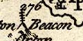
Orton Beacon |
|
Lakes Guides menu.