 Geological Map of the Lake District

|

|
|
|
map type:- Garnett 1850s-60s K |
|
|
|
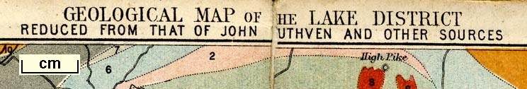
Geological Map of the Lake District, scale about 6 miles
to 1 inch, reduced from John Ruthven's map etc, by J
Bartholomew, Edinburgh, published by John Garnett,
Windermere, Westmorland, and by Simpkin, Marshall and Co,
London, 1865.
Included as frontispiece in the guide book, Ascents and Passes in the Lake District of England, by Herman Prior. |
||

|
Ruthven 1855 | |
|
(example JandMN (235_2))
|
||
| map feature:- | folded (2x2) & up is N & scale line & sea plain & coast form lines & rivers & lakes & settlements & roads & railways & geology & stratigraphical column | |
| inscription:- |
printed top
GEOLOGICAL MAP OF THE LAKE DISTRICT / REDUCED FROM THAT OF JOHN RUTHVEN AND OTHER SOURCES |
|
| inscription:- |
printed bottom left, centre, right
All Rights Reserved / Windermere; J. Garnett. / J. Bartholomew, Edinr. |
|
| wxh, folded:- | 7.5x10.5cm | |
| wxh, sheet:- | 15x20.5cm | |
| wxh, map:- | 144x189mm | |
| inscription:- |
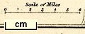
printed with scale line
Scale of Miles |
|
| scale line:- | 6 miles = 24.4 mm | |
| scale:- | 1 to 400000 ? (1 to 395740 from scale line) | |
|
||
| sources:- |
JandMN Collection |
|
| items seen (illustrated items in bold):- | ||
|
|
JandMN (235_2) -- geological map -- Geological Map of the Lake District | |