 Map of the English Lakes

|

|
|
|
map type:- Garnett 1850s-60s H |
|
|
|
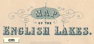
Map of the English Lakes, in Cumberland, Westmorland and
Lancashire, scale about 3.5 miles to 1 inch, published by
John Garnett, Windermere, Westmorland, 1850s-60s.
|
||
|
(map example JandMN (82_1))
|
||
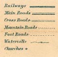
| map feature:- | folded & north point & up is N (but tipped in sideways) & scale line & sea plain & coast line & coast form lines & rivers & lakes & relief & hill hachuring & parks & county & settlements & roads & railways & canals | |
| inscription:- |
printed lower left
MAP / OF THE / ENGLISH LAKES. |
|
| inscription:- |
printed bottom
PUBLISHED BY JOHN GARNETT WINDERMERE |
|
| inscription:- |
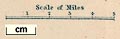
printed above scale line
Scale of Miles |
|
| scale line:- | 5 miles = 36.9 mm | |
| scale:- | 1 to 220000 ? (1 to 218068 from scale line) | |
| wxh, folded:- | 10x14.5cm | |
| wxh, sheet:- | 38x48cm | |
| wxh, map:- | 357x462mm | |
|
||
|
||
| sources:- |
JandMN Collection |
|
| items seen (illustrated items in bold, * have map squares etc):- | ||

|
JandMN (82_1) -- map -- Map of the English Lakes * | |