 Garnett 1850s-60s H

|

|
|
|
item:- JandMN (82_1) image:- © see bottom of page |
click to enlarge |
|

|
menu with map squares and placename index | |
|
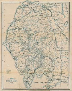
Map of the English Lakes, in Cumberland, Westmorland and
Lancashire, scale about 3.5 miles to 1 inch, published by
John Garnett, Windermere, Westmorland, 1850s-60s.
Tipped in before the frontispiece in Black's Picturesque Guide to the English Lakes, published by Adam and Charles Black, 6 North Bridge, Edinburgh, Lothian, 5th edn 1852. The evidence of railways included on the map puts its date about 1876. This map does not belong in this guide book. An advertisement for the guide book, on the front end papers, states 'With a minutely accurate Map, by W Hughes ...' This is not this map. |
||
|
|
Garnett 1850s-60s H | |
| map feature:- | folded & north point & up is N (but tipped in sideways) & scale line & sea areas & sea plain & coast line & coast form lines & rivers & lakes & relief & hill hachuring & parks & county & settlements & roads & railways & canals | |
| inscription:- |
printed lower left
MAP / OF THE / ENGLISH LAKES. |
|
| inscription:- |
printed bottom
PUBLISHED BY JOHN GARNETT WINDERMERE |
|
| inscription:- |
printed above scale line
Scale of Miles |
|
| scale line:- | 5 miles = 36.9 mm | |
| longitude, Kendal:- | 2d 47m W | |
| scale:- | 1 to 220000 ? (1 to 218068 from scale line) | |
| wxh, folded:- | 10x14.5cm | |
| wxh, sheet:- | 38x48cm | |
| wxh, map:- | 357x462mm | |
|
|
notes | |