 Road from London to Carlisle

|

|
|
|
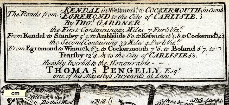
map type:- Gardner 1719 |
|
|
|
Road strip maps with sections in Westmorland and
Cumberland etc, scales about 2 miles to 1 inch, reduced from
maps by Ogilby, 1675, by Thomas Gardner, published by J
Tonson, Strand and by J Watts, Wild Court, London, 1719.
Published in 'A POCKET-GUIDE TO THE English TRAVELLER: Being a Compleat SURVEY and ADMEASUREMENT Of all the Principal ROADS and most Considerable Cross-ROADS in ENGLAND and WALES. In One Hundred COPPER-PLATES. / LONDON: Printed for J. TONSON at Shakespear's Head over-against Katherine-Street in the Strand, and J. WATTS at the Printing-Office in Wild-Court near Lincoln's-Inn Fields. MDCCXIX.' ie 1719. There is a title page and a few pages of text; the atlas size is 6 3/4 x 7 1/4 ins; the maps are reduced from Ogilby's maps of 1675. The plates relevant to Westmorland are:- Plate 38 Road from London to Carlisle. Plate 96 Road from Kendal to Cockermouth, etc. Also, relevant to Cumberland:- Plate 62 Road from Carlisle to Barwick |
||

|
Ogilby 1675 | |
| scale:- | 1 to 130000 ? (guess, not quite 2 miles to 1 inch) | |
| references:- |
Gardner, Thomas: 1719: Pocket-Guide To The English
Traveller: (London) |
|
| sources:- |
Chubb 1927 (CXXXVII) Armitt Library |
|
| items seen (illustrated items in bold):- | ||
|
|
Armitt Library : ALMC2008.14.107 -- strip map (pl.96) -- From Kendal to Cockermouth -- From Egremond to Carlisle | |