 Gardner 1719

|

|
|
|
item:- Armitt Library : ALMC2008.14.107 image:- © see bottom of page |
click to enlarge |
|
|
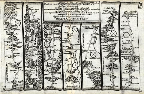
Road strip map, uncoloured engraving, From Kendal to
Cockermouth, and From Egremond to Carlisle, in Westmorland
and Cumberland, scales about 2 miles to 1 inch? by Thomas
Gardner, by Thomas Gardner, published by J Tonson, Strand
and by J Watts, Wild Court, London, 1719.
Pl.96 in a Pocket Guide to the English Traveller - from Kendal, through Stanlay ie Staveley, Ambleside, Westmorland; then Keswick, to Cockermouth, Cumberland AND from Egremond, through Cockermouth, to Carlisle, Cumberland. Dedicated to Thomas Pengelly. The map is derived from those by Ogilby 1675. |
||

|
Gardner 1719 | |
| map feature:- | plain cartouche & dedication & compass rose & up is destination & rivers & lakes & relief & hillocks & woods & parks & county & settlements & roads & road distances & table of distances | |
| inscription:- |
printed title cartouche, top
The Roads from KENDAL in Westmerld. to COCKERMOUTH in Cumb. / EGREMOND to the City of CARLISLE. / By THOMAS GARDNER. / The First Containing 43 Miles 7 Furlongs Vizt. / From Kendal to ... / ... / The Second Containing 39 Miles 4 Furlongs, Vizt. / From Egremond to ... / ... / Humbly Inscrib'd to the Honourable / THOMAS PENGELLY, Esqr. / one of his Majesty's Serjeants at Law. |
|
| inscription:- |
printed bottom right
96 |
|
| wxh, sheet:- | 29x18.5cm | |
| wxh, map:- | 27x17cm | |