 Ellis 1765

|

|
|
|
map type:- Ellis 1765 |
|
|
|
Maps, A Modern Map of Westmoreland, scale about 6 miles
to 1 inch, and of Cumberland, by John Ellis, London, 1765,
published by Carington Bowles, St Pauls Churchyard, and
Robert Sayer, Fleet Street, London, 1766.
Published in Ellis's English Atlas: Or, A Compleat Chorography of England and Wales by Robert Sayer, The Golden Buck, Fleet-Street and Carington Bowles, St Paul's Churchyard, 1765; published 1765-1824. Published in 'The New English Atlas; Being The Completest Sett Of Modern Maps Of England and Wales, With their Adjacent Islands, Ever Yet Published: Accurately drawn from Actual Surveys, by the most able Geographers, And Engrav'd in the best Manner, By J. Ellis, and Others, On Fifty-Four Copper-Plates. Containing The Particular County Maps. In which are Correctly laid down all the Cities, Towns, Rivers, Roads, and every thing remarkable therein: Also Five Large, Elegant and Useful General Maps, viz. 1. Of England and Wales. 2. The Rivers of England and Wales. 3. A Post-Map of Ditto with great Part of Scotland. 4. Of London, and Country twenty-five Miles round. 5. Britain as divided under the Saxon Heptarchy. London: Printed for Robert Sayer, at the Golden Buck, near Serjeant's Inn, Fleet-Street, and Carington Bowles, near the Chapter House, St. Paul's Church Yard. MDCCLXV.' ie 1765. Published in 'Ellis's English Atlas: Or, A Compleat Chorography of England and Wales: in Fifty Maps Containing more Particulars than any other Collection of the Same Kind. The Whole Calculated for the Use of Travellers, Academies, and of all those who desire to Improve in the Knowledge of their Country. From the latest Surveys of the Several Counties; Engraved by, and under the Direction of, J. Ellis. London: Printed for Robert Sayer, at the Golden Buck, near Serjeant's Inn, in Fleet-Street; and Carington Bowles, next the Chapter-House, in St. Paul's Church-Yard. Price 10s. 6d. in Red Leather for the Pocket. M DCC LXVI.' ie 1766. Published in 'Ellis's English Atlas: ... J. Ellis. London: Printed for Carington Bowles, next the Chapter-House, in St. Paul's Church-Yard; and Robert Sayer, at the Golden Buck, near Serjeant's Inn, in Fleet-Street. Price 10s. 6d. in Red Leather for the Pocket. M DCC LXVI.' ie 1766. These last two items are the same but for the order of publishers in the imprint, personalised to suit their shop. The atlas has a title page, list of maps, etc; its size is 11 1/2 x 9 ins; the maps are plain on the reverse. Published in 'Ellis's English Atlas ... in Fifty-Four Maps. ... With the Addition of Four Maps, viz. Of the Rivers of England and Wales; of Twenty-five miles of the Country round London; of the Island of Jersey; and of Guernsey, Sark, Alderney and Burhou. Engraved by ... J. Ellis. London: Printed for Carington Bowles, next the Chapter House, in St. Paul's Church-Yard; and Robert Sayer, at the Golden Buck, near Serjeant's Inn, in Fleet Street. Price 15s. in Red Leather for the Pocket. MDCC LXVI.' ie 1766. Published as above with publisher's names reversed. This may or may not be later than the first issue; maps are printed both sides of the paper. Published in 'Atlas Britannique, Ou Chorographie Complette De L'Angleterre Et De Principaute de Galles. En 54 Cartes Executee par les plus Habiles Graveurs, Et dans lesquelle on a reuni tous les Details qui peuvent interesser les Amateurs de la Geographie. A Londres: Chez Robert Sayer, Marchand de Cartes & d'Estampes. M DCC LXVI.' ie 1766. The map is unchanged in this and the subsequent editions. Published in another edition 'Ellis's English Atlas ... London: Printed for Carington Bowles, Map and Print-Seller, at No.69, in St. Paul's Church-Yard. 1768. ...' Published in another edition '... Printed for Robert Sayer, Map and Printseller, No.53, in Fleet Street; Thomas Jeffery's, Geographer to his Majesty the Corner of St. Martin's Lane, Charing-Cross; A. Dury in Duke's-Court, St. Martin's-Lane, and at the Map and Print Shop No.92, under the Royal Exchange, Cornhill, 1768.' The 1768 edition has a 'Modern Map of the Post Roads ...' Published in another edition 'ELLIS'S ENGLISH ATLAS: OR A COMPLEAT CHOROGRAPHY OF ENGLAND AND WALES: In FIFTY MAPS, Containing more Particulars than any other Collection of the Same Kind. The Whole Calculated for the USE of TRAVELLERS, ACADEMIES, and of all those who desire to Improve in the KNOWLEDGE of their COUNTRY. From the latest SURVEYS of the Several COUNTIES; Engraved by, and under the Direction of, J. ELLIS. / LONDON Printed for Robert Sayer, Map and Printseller, No.53. in Fleet-Street; and at the Map and Print Shop No.92, under the Royal-Exchange, Cornhill. 1773.' The 1773 edition has 'A Chart of the Distances of all the Cities and chief Towns in England and Wales ... P. Luckombe fecit 1775. ...' Published in another edition '... London, Printed for R. Sayer and J. Bennett, Map, Chart, and Print Sellers, No.53, Fleet-Street, 1777.' Published in another edition 'Ellis's English Atlas: Or, A Complete Chorography of England and Wales ... London: Printed for Carington Bowles, at his Map and Print Warehouse, No.69, St. Paul's Church Yard. (Price 15s. in Red Leather for the Pocket.)' about 1782. Published in another edition 'Ellis's English Atlas: Or, A Complete Chorography of England and Wales ... London: Printed for Carington Bowles, at his Map and Print Warehouse, No.69, St. Paul's Church Yard. (Price 10s.6d. in Red Leather for the Pocket.)' about 1786. Published in another edition 'Ellis's English Atlas: Being Accurate Maps Of All The Counties In England And Wales ... London: Printed for Robert Sayer, No.53, Fleet Street.' about 1790. Published in a parallel edition 'Ellis's English Atlas: Being Accurate Maps Of All The Counties In England And Wales ... London: Printed for Carington Bowles, at his Map and Print Warehouse, No.69, St. Paul's Church Yard. (Price 10s.6d.) about 1790. Published in another edition 'Ellis's English Atlas: ... London: Printed for Robert Sayer, No.53, Fleet Street.' published by Laurie and Whittle, about 1796. |
||
|
(map example JandMN (6))
|
||
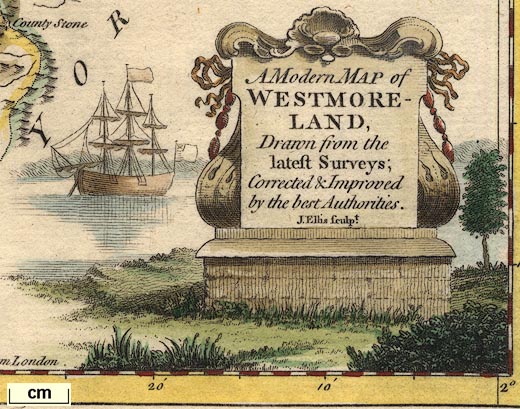
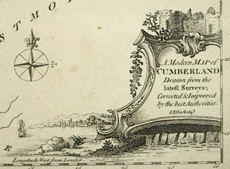
| map feature:- | title cartouche & monumental cartouche & table of symbols & sea plain & coast shaded & compass rose & up is N & scale line & lat and long scales & rivers & lakes & relief & hillocks & woods & parks & county & settlements & roads | |
| inscription:- |
printed title cartouche, lower right
A Modern MAP of / WESTMORE- / LAND, / Drawn from the / latest Surveys; / Corrected & Improved / by the best Authorities. / J. Ellis sculpt. |
|
| inscription:- |
printed bottom centre
Printed for Carington Bowles in St. Pauls Churchyard, & Robt. Sayer in Fleet Street. |
|
| scale line:- | 10 miles = 41.2 mm | |
| scale:- | 1 to 390000 ? (1 to 390617 from scale line) | |
| wxh, sheet:- | 29x22.5cm | |
| wxh, plate:- | 263x203mm | |
| wxh, map:- | 251x192mm | |
|
||
|
||
| references:- |
Ellis, John: 1765: New English Atlas: Sayer, Robert &
Bowles, Carington (London) Ellis, John: 1766 (two editions): Ellis's English Atlas & Compleat Chorography of England and Wales: Sayer, Robert & Bowles, Carington (London) Ellis, John: 1766: Atlas Britannique & Chorographie Complette De L'Angleterre Et De Principaute de Galles: Sayer, Robert (London) Ellis, John: 1768 & 1782 & 1786: Ellis's English Atlas & Compleat Chorography of England and Wales: Bowles, Carington (London) Ellis, John: 1768: Ellis's English Atlas : Sayer, Robert & Jefferys, Thomas & Dury, Andrew (London) Ellis, John: 1773: Ellis's English Atlas & Compleat Chorography of England and Wales: Sayer, Robert (London) Ellis, John: 1777: Ellis's English Atlas & Compleat Chorography of England and Wales: Sayer, Robert & Bennett, John (London) Ellis, John: 1790: Ellis's English Atlas: Sayer, Robert (London) Ellis, John: 1790: Ellis's English Atlas: Bowles, Carington (London) Ellis, John: 1796: Ellis's English Atlas: Laurie, Robert & Whittle, James (London) |
|
| sources:- |
Chubb 1927 (CCXXVII) JandMN Collection Wordsworth Trust Collection Armitt Library Kendal Library Maps Carlisle Library Maps |
|
| items seen (illustrated items in bold):- | ||

|
Armitt Library : ALMC2008.14.17 -- map -- Modern Map of Westmoreland | |
|
|
Carlisle Library : Map 140 -- map -- Modern Map of Cumberland | |
|
|
Carlisle Library : Map 351 -- map -- Modern Map of Westmoreland | |
|
|
Dove Cottage : 2007.38.104 -- map -- Modern Map of Westmoreland | |
|
|
Dove Cottage : 2007.38.105 -- map -- Modern Map of Westmoreland | |
|
|
JandMN (6) -- map -- Modern Map of Westmoreland | |
|
|
Kendal Library : Map 23 -- map -- Modern Map of Westmoreland | |
|
|
Kendal Library : Map 24 -- map -- Modern Map of Westmoreland | |