 Ellis 1765

|

|
|
|
item:- JandMN (6) image:- © see bottom of page |
click to enlarge |
|
|
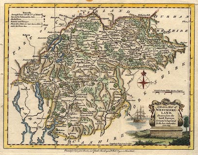
Map, hand coloured engraving, A Modern Map of
Westmoreland ie Westmorland, scale about 6 miles to 1 inch,
by John Ellis, London, 1765, published by Carrington Bowles,
St Pauls Churchyard, and Robert Sayer, Fleet Street, London,
1766.
Published in Ellis's English Atlas: Or, A Compleat Chorography of England and Wales. |
||

|
Ellis 1765 | |
| map feature:- | monumental cartouche & table of symbols & sea plain & coast shaded & compass rose & up is N & scale line & lat and long scales & rivers & lakes & relief & hillocks & woods & parks & county & settlements & roads | |
| inscription:- |
printed title cartouche, lower right
A Modern MAP of / WESTMORE- / LAND, / Drawn from the / latest Surveys; / Corrected & Improved / by the best Authorities. / J. Ellis sculpt. |
|
| inscription:- |
printed bottom centre
Printed for Carrington Bowles in St. Pauls Churchyard, & Robt. Sayer in Fleet Street. |
|
| inscription:- |
printed above scale line
British Statute Miles 69 to a Degree |
|
| scale line:- | 10 miles = 41.2 mm | |
| longitude, Kendal:- | 2d 51m W | |
| scale:- | 1 to 390000 ? (1 to 390617 from scale line) | |
| wxh, sheet:- | 29x22.5cm | |
| wxh, plate:- | 263x203mm | |
| wxh, map:- | 251x192mm | |
|
|
notes | |