 Ellis 1765

|

|
|

|
back to object record | |
| MAP FEATURES | ||
|
|
||
|
title cartouche
monumental cartouche map maker engraver publisher |
Printed in a monumental title cartouche, lower
right:-
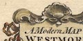
A Modern MAP of WESTMORELAND, Drawn from the latest Surveys; Corrected & Improved by the best Authorities. J. Ellis sculpt. The cartouche has a plinth with an urn, decorations of scallop shell and scrolls, ribbons, etc. Behind the monument is a coastal landscape and a three masted merchant ship. Printed bottom centre:- Printed for Carington Bowles in St. Pauls Churchyard, & Robt. Sayer in Fleet Street. |
|
|
|
||
| table of symbols |
Printed upper left are:-
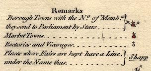
Remarks Borough Towns with the No. of Membrs. they send to Parliament by Stars ... [circle, tower, asterisks] Market Towns ... [circle, tower] Rectories and Vicarages ... [circle with cross] Places where Fairs are kept have a Line under the name thus ... Shapp [underlined] |
|
|
|
||
|
orientation
compass rose up is N |
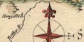
The map has a compass rose; circle, star points for cardinal directions, lines for half cardinal directions, North marked by a fleur de lys, east marked by a cross, tinted red and white. The map is printed with North at the top of the sheet. |
|
|
|
||
|
scale line
scale |
Printed on the right below centre is a scale of:-
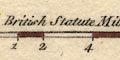
British Statute Miles 69 to a Degree chequered and labelled at mile then two mile intervals, tinted red and white. The 10 miles = 41.2 mm gives a scale 1 to 390617. The map scale is about 1 to 390000 6 miles to 1 inch |
|
|
|
||
|
lat and long
lat and long scales |
Printed in the map borders are scales of latitude and
longitude for a slanted rectangular projection; chequered at
1 minute, labelled at 10 minute intervals, tinted red and
white. The bottom scale is labelled:-
Longitude West from London. From the scales the:- longitude, Kendal = 2d 51m W implying a prime meridian 6m W of Greenwich (St Paul's is about 3m W). The meridians at 2 and 3 degrees are drawn across the map, vestiges of a graticule. The 54 and 55 degree parallels are outside the map area, but to make the position certain the 40mN mark is labelled:- 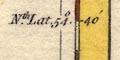
Nth. Lat. 54[d] 40[m] The map includes from 2d0m to 3d41m W, from 54d 6m to 54d 44m N; the whole of Westmorland. |
|
|
|
||
|
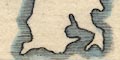
sea area
sea plain |
The small sea areas either side of the Cartmel peninsula
are plain, not tinted.
|
|
|
|
||
|
coast line
coast shaded foreshore |
The coast line around the Leven and Kent Estuaries is emphasised by shading, tinted blue. A small amount of foreshore shallows is marked in part of the Kent Estuary. |
|
|
|
||
|
rivers
bridges |
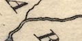
Rivers are drawn by a double line, then single line tapering upstream. Some rivers are labelled, eg:- Lone of Lune R. Burrow R. Ken or Can R. Ruthy R [ie Rothay, but wrongly labelling the Trout Beck] The major rivers are shown, with numerous tributaries. Bridges are implied where a road crosses and interrupts a stream, but might be marked by a double line across a stream, without a road; Kendal provides interesting examples. Some bridges are labelled, eg:- 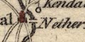
Nether Bridge [Kendal] Levensbridge Burrow Br [Low Borrow Bridge] |
|
|
|
||
| lakes |
Lakes are drawn in outline, the shore line shaded, tinted
blue. Some are labelled:-
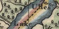
Ulles Lake Haws Water [Hayes Water] Broad Water [Haweswater] Winander Mere And others can be recognised:- Brothers Water Rydal Water [not tinted] Grasmere Easedale Tarn [?] Kentmere tarn Also notice a large area with ?tussock symbols between Kellet and the Lune labelled:- Lenebridge Fen and in Lancashire:- Coniston Mere |
|
|
|
||
|
relief
hillocks |
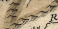
Relief is indicated by hillock symbols, shaded to the east, tinted brown. These are drawn in lines to suggest ranges of hills, but I wouldn't put too much trust in their veracity. A few hillocks are larger, and labelled, eg:- 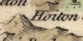
Hoiton Cragg [?Farleton Knott] Dufton Pike Murton Pike The choice of these particular hills probably depends more on who was being copied than an assessment of ground truth. There are some other hills labels, eg:- Whinfield Hill Helvillon Hill Jefferys Hill but it is not clear what is labelled. Kelloplaw Hill is labelled because it is the meet of four counties. |
|
|
|
||
|
woods
trees forests |
Groups of tree symbols, with some suggestion of underbush, the are tinted green, indicate woodland. Most of the woodlands are not labelled, but see:- Mallerstang Forest Milburn Forest Wingfield Forest |
|
|
|
||
| parks |
Parks are drawn in outline with fence palings, the
interior wood, tinted green. The park might be labelled, or
named by its house, eg:-
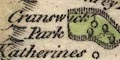
Cranswick Park Preston Hall Barton Park And other parks might be recognised. |
|
|
|
||
| county |
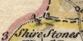
The county boundary is a bold dashed line, adjacent counties are divided by a fine dotted line. Each county is tinted along the inside of its boundary; Westmorland pale brown, Lancashire yellow, Cumberland pink, Durham brown, Yorkshire green. Adjacent counties are labelled, eg:- PART OF CUMBERLAND PART OF LANCASHIRE Some features are shown because they are on the county boundary?- Kelloplaw Hill [Wmd/Cmd/Dhm/Yrk] Rey Cross [Wmd/Yrk] Hollow Mill Cross [Wmd/Yrk] County Stone [Wmd/Yrk/Lan] Birkstone [Wmd/Lan] 3 Shire Stones [Wmd/Lan/Cmd] Dunmail Raise Stones [Wmd/Cmd] A few features are shown outwith the county for the sake of continuity. |
|
|
|
||
|
settlements
electoral data fairs |
Settlements are marked by a circle with added elements,
further differentiated by style of labelling.
|
|
| towns |
circle, buildings, tower, tinted red; labelled in upright
lowercase text, eg:-
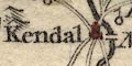
Kendal Orton and in upright block caps:- APPLEBY |
|
|
the de jure county town, with two asterisks indicating it
returns two members to Parliament.
|
||
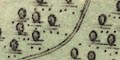
|
villages
hamlets |
circle; labelled in italic lowercase text, eg:-
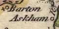
Askham Stanley [Staveley] Sleddale the last an example of a community with no nucleated settlement. A cross attached to the circle indicates a rectory or vicarage; and underline indicates a fair. Village, hamlet, house cannot be distinguished. 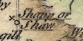
Shapp or Shaw |
|
| castles |
circle with a flag, eg:-
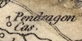
Pendragon Castle Kendal Castle |
|
|
|
||
| roads |

A network of roads is drawn by double line. Destinations of some roads is labelled at the county boundary, eg:- fr. Lancaster to Barnard Cas. or the road might be extended to a town in the adjacent county, as Penrith and Keswick. |
|
|
|
||
| miscellaneous | ||
|
|
||
|
antiquities
stones |
A stone is drawn by the road at the boundary with
Lancashire, labelled:-
Birkstone Three upright stones are labelled:- 3 Shire Stones upon Wry Nose Head A group of upright stones is labelled:- Dunmail Raise Stones A group of upright stones, where the road from Orton joins the Kendal to Shap road, is labelled:- 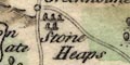
Stone Heaps A stone on a hillock at the meet of Westmorland, Yorkshire and Lancashire is labelled:- County Stone |
|
|
|
||
| crosses |
A cross on the Durham border is labelled:-
Rey Cross and on the Yorkshire border is:- 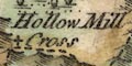
Hollow Mill Cross |
|
|
|
||
|
mines
copper mines lead mines coal mines |
There are dots, roughly diamond shape, labelled:-
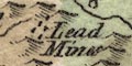
Lead Mines south of Milburn Forest, and south of Eaglehurst, in the north east of the county. Labelled, but not marked, are:- Copper Mines in upper Langdale And by Stainmoor is:- Coal Pitts |
|
|
|
||
| tanyards |
A circle south of the Barnard Castle road is
labelled:-
Tanpitts |
|
|
|
||
|
antiquities
earthworks |
A double circle south west of Eamont Bridge is
labelled:-
King Arthurs Round Table |
|
Lakes Guides menu.