 Cowley 1743

|

|
|
|
map type:- Cowley 1743 |
|
|
|
Maps, Improved Map of Westmoreland, scale about 5.5 miles
to 1 inch, and Improver Map of Cumberland, by J Cowley,
London, 1743; published 1743-45.
Published in 'The Geography Of England: Done in the Manner of Gordon's Geographical Grammar, Each County being consider'd under the following Heads, viz. The name, Situation, Air, Soil, Commodities, Rivers, Chief Towns, Noblemen's Seats, Curiosities Natural and Artificial, Remarkable Persons, Various Particulars. To each County is Prefix'd A compleat Mapp from the Latest and Best Observations, shewing the Chief Towns, Parks, Rivers and Roads, both direct and across. Also A Separate Mapp of England, of the Roads, Of the Channel, and a Plan of London. Likewise by Way of Introduction, A Clear and Distinct View of our Constitution, And Every Branch of the Legislature. London: Printed for R. Dodsley, at Tully's Head in Pall Mall, M,DCC,XLIV.' ie 1744, but published 1743. the book size is 4 1/2 x 6 1/2 ins; it contains 56 folded maps. Published in 'A New Sett of Pocket Mapps Of all the Counties of England and Wales. Shewing, The Situation of all the Cities, Boroughs, Market-Towns, and most considerable Villages, with the Distances between each. Also the Rivers and Roads both direct and across. Together with A Separate Mapp of England, a Plan of the Roads, and a Chart of the Channel. London: Printed for R. Dodsley in Pall-Mall, and M. Cooper in Pater-noster Row. 1745.' The atlas size is 6 1/4 x 8 ins; the map is unchanged. Published in another edition 1745. Another edition 1765 had no maps. |
||
|
(map example private collection(11))
|
||
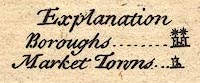
| map feature:- | title cartouche & drape cartouche & compass rose & scale line & lat and long scales & coast line & coast shaded (sea coast) & coast form lines (in estuaries) & rivers & forests (labelled, no tree symbols) & county & settlements & roads & road distances & table of symbols | |
| inscription:- |
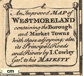
printed title cartouche, lower right
An Improved MAP of / WESTMORELAND / containing the Borough / and Market Towns / with those adjoyning; also, / its Principal Roads / and Rivers by I. Cowley / Geor. to his MAJESTY |
|
| inscription:- |
water mark:
part of a fleur de lys? |
|
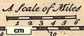
| scale:- | 1 to 350000 ? (1 to 346095 from scale line assuming a statute mile) | |
| scale line:- | 6 miles = 27.9 mm | |
| wxh, page:- | 16x20cm | |
| wxh, map:- | 132x178mm | |
|
||
|
||
| references:- |
Dodsley, R: 1744: Geography of England: (London) Dodsley, R:
1745: New Sett of Pocket Mapps Of all the Counties of
England and Wales: Dodsley, R & Cooper, M (London) |
|
| sources:- |
Chubb 1927 (CLXXXI) private collection Armitt Library |
|
| items seen (illustrated items in bold):- | ||

|
Armitt Library : ALMC2008.14.89 -- map -- Improved Map of Westmoreland | |
|
|
private collection (11) -- map -- Improved Map of Westmoreland | |