 Cowley 1743

|

|
|
|
item:- private collection (11) image:- © see bottom of page |
click to enlarge |
|
|
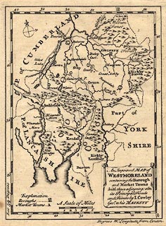
Map, uncoloured engraving, Improved Map of Westmoreland,
ie Westmorland, scale about 5.5 miles to 1 inch, by J
Cowley, London, probably published in a Geography of
England, by Robert Dodsley, The Tully's Head, Pall Mall,
London, 1744-45.
A crude check of the map's declared scale against the distance between one pair of towns, Penrith Kendal, suggests the map maker's mile is about 1.3 statute miles. |
||

|
Cowley 1743 | |
| map feature:- | drape cartouche & compass rose & scale line & lat and long scales & sea areas & coast line & coast shaded (sea coast) & coast form lines (in estuaries) & rivers & forests (labelled, no tree symbols) & county & settlements & roads & road distances & table of symbols | |
| inscription:- |
printed title cartouche, lower right
An Improved MAP of / WESTMORELAND / containing the Borough / and Market Towns / with those adjoyning; also, / its Principal Roads / and Rivers by I. Cowley / Geor. to his MAJESTY |
|
| inscription:- |
water mark:
part of a fleur de lys? |
|
| scale line:- | 6 miles = 27.9 mm | |
| scale:- | 1 to 350000 ? (1 to 346095 from scale line assuming a statute mile) | |
| scale:- | 1 to 460000 ? (from measured Penrith Kendal distance) | |
| wxh, page:- | 16x20cm | |
| wxh, map:- | 132x178mm | |
|
|
notes | |