 Cowley 1743

|

|
|
|
item:- Armitt Library : ALMC2008.14.89 image:- © see bottom of page |
click to enlarge |
|
|
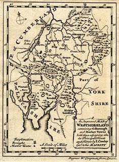
Map, uncoloured engraving, Improved Map of Westmoreland,
ie Westmorland, scale about 5.5 miles to 1 inch, by J
Cowley, London, 1743?
Probably included in a Geography of England, by Robert Dodsley, The Tully's Head, Pall Mall, London, 1744-45. |
||

|
Cowley 1743 | |
| map feature:- | drape cartouche & compass rose & scale line & lat and long scales & sea areas & coast line & coast shaded (sea coast) & coast form lines (in estuaries) & rivers & forests (labelled, no tree symbols) & county & settlements & roads & road distances & table of symbols | |
| inscription:- |
printed title cartouche, lower right
An Improved MAP of / WESTMORELAND / containing the Borough / and Market Towns / with those adjoyning; also, / its Principal Roads / and Rivers by I. Cowley / Geor. to his MAJESTY |
|
| inscription:- |
printed above scale line
A Scale of Miles |
|
| scale line:- | 6 miles = 27.8 mm | |
| scale:- | 1 to 350000 ? (1 to 347340 from scale line assuming a statute mile) | |
| wxh, page:- | 14.5x19.5cm | |
| wxh, map:- | 131x178mm | |