 Bowles 1785

|

|
|
|
map type:- Bowles 1785 |
|
|
|
Maps, Bowles's Reduced Map of Westmoreland, scale about
7.5 miles to 1 inch, and of Cumberland? by Carington Bowles,
69 St Paul's Churchyard, London, 1785.
Published in '[Bowles's Pocket Atlas of the Counties of South Britain or England and Wales, Drawn to One Scale: By which the true proportion they severally bear to each other may be easily ascertained, with the Measured Distances from London by the nearest Roads annexed, to all the Cities, Borough and Market Towns in the Kingdom. Being the only Set of Counties, ever Published on this Plan. London. Printed for and Sold by the Proprietor Carington Bowles, No.69 in St Paul's Church Yard.]' |
||
|
(example Armitt Library : ALMC2008.14.74)
|
||
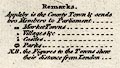
| map feature:- | title cartouche & table of symbols & compass rose & up is N & scale line & lat and long scales & lat and long grid (minimal) & sea plain & coast shaded & rivers & lakes & relief & hillocks & woods & trees & forests & parks & county & settlements & roads & distances from London | |
| inscription:- |
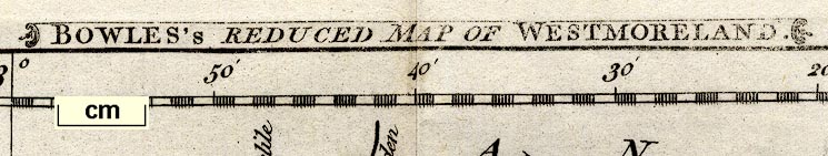
printed title cartouche, top
BOWLES'S REDUCED MAP OF WESTMORELAND. |
|
| wxh, sheet:- | 27.5x21.5cm | |
| wxh, plate:- | 212x173mm | |
| wxh, map:- | 204x167mm | |
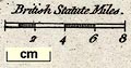
| inscription:- |
printed above scale line
British Statute Miles. |
|
| scale line:- | 8 miles = 27.8 mm | |
| scale:- | 1 to 460000 ? (1 to 463121 from scale line) | |
| longitude, Kendal:- | 2d 52m W | |
|
||
|
||
| references:- |
Bowles, Carington: 1785: Bowles's Pocket Atlas of the
Counties of South Britain or England and Wales: Bowles,
Carington (London) |
|
| sources:- |
Chubb 1927 (CCLVI) Armitt Library |
|
| items seen (illustrated items in bold):- | ||

|
Armitt Library : ALMC2008.14.74 -- map -- Bowles's Reduced Map of Westmoreland | |
|
|
Armitt Library : ALMC2008.14.75 -- map -- Bowles's Reduced Map of Westmoreland | |