 Bowles 1785

|

|
|
|
item:- Armitt Library : ALMC2008.14.74 image:- © see bottom of page |
click to enlarge |
|
|
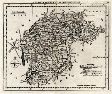
Map, uncoloured engraving, Bowles's Reduced Map of
Westmoreland, scale about 7.5 miles to 1 inch, by Carington
Bowles, 69 St Paul's Churchyard, London, 1785.
Included in Bowles's Pocket Atlas of the Counties of South Britain or England and Wales. |
||

|
Bowles 1785 | |
| map feature:- | plain cartouche (?) & table of symbols & compass rose & up is N & scale line & lat and long scales & lat and long grid (minimal) & sea plain & coast shaded & rivers & lakes & relief & hillocks & woods & forests & parks & county & settlements & roads & distances from London | |
| inscription:- |
printed title cartouche, top
BOWLES'S REDUCED MAP OF WESTMORELAND. |
|
| inscription:- |
printed above scale line
British Statute Miles. |
|
| scale line:- | 8 miles = 27.8 mm | |
| longitude, Kendal:- | 2d 51.8m W | |
| wxh, sheet:- | 27.5x21.5cm | |
| wxh, plate:- | 212x173mm | |
| wxh, map:- | 204x167mm | |
| scale:- | 1 to 460000 ? (1 to 463121 from scale line) | |
|
|
notes | |