 Westmorland

|

|
|
|
map type:- Black 1892 |
|
|
|
Maps, Westmorland, scale about 6 miles to 1 inch,
Cumberland? and Lake District, scale about 3 miles to 1
inch, by John Bartholomew and Co, Edinburgh Geographical
Institute, published by A and C Black, London, 1892.
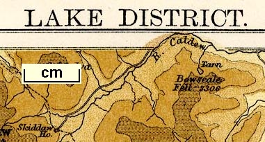
Included in Black's Handy Atlas of England and Wales. plate 43 - Westmorland. plate 64 - Lake District, with layer colouring. |
||
|
(example JandMN (314))
|
||
| map feature:- | up is N & scale line & sea tinted & coast line & rivers & lakes & relief & hill hachuring & forests & county & settlements & roads & railways & canals | |
| inscription:- |
printed top
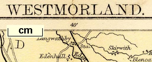
Black's Handy Atlas of England & Wales WESTMORLAND. Plate 43. |
|
| inscription:- |
printed bottom, left, right, centre
The Edinburgh Geographical Institute / John Bartholomew & Co. / Published by A. & C. Black, London. |
|
| wxh, page:- | 13.5x20.5cm | |
| wxh, sheet:- | 27x20.5cm | |
| wxh, map:- | 245x171mm | |
| inscription:- |
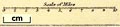
printed with scale line
Scale of Miles |
|
| scale line:- | 10 miles = 41.4.mm | |
| scale:- | 1 to 390000 ? (1 to 388730 from scale line assuming a statute mile) | |
|
||

|
||
| sources:- |
JandMN Collection Smith 1985 (V.e) |
|
| items seen (illustrated items in bold):- | ||

|
JandMN (314) -- map -- Westmorland | |
|
|
JandMN (315) -- map -- Lake District | |