 Black 1892

|

|
|
|
item:- JandMN (315) image:- © see bottom of page |
click to enlarge |
|
|
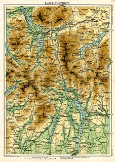
Map, colour printed, Lake District. scale about 3 miles
to 1 inch, by John Bartholomew and Co, Edinburgh
Geographical Institute, published by A and C Black, London,
1892.
Plate 64 from Black's Handy Atlas of England and Wales. |
||

|
Black 1892 | |
| map feature:- | up is N & scale line & relief & rivers & lakes & contours & layer colouring & spot heights & settlements & roads & railways | |
| inscription:- |
printed top
LAKE DISTRICT. |
|
| inscription:- |
printed right
Black's Handy Atlas of England & Wales Plate 64. |
|
| inscription:- |
printed bottom, left, right
The Edinburgh Geographical Institute / John Bartholomew & Co. |
|
| inscription:- |
printed with scale line
SCALE 3 MILES TO AN INCH. |
|
| scale line:- | 6 miles = 50.6 mm | |
| wxh, page:- | 13.5x20.5cm | |
| wxh, sheet:- | 20.5x27cm | |
| wxh, map:- | 177x248mm | |
| scale:- | 1 to 190000 ? (1 to 190831 from scale line assuming a statute mile) | |