 Black 1892

|

|
|
|
item:- JandMN (314) image:- © see bottom of page |
click to enlarge |
|
|
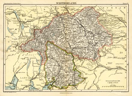
Map, colour printed, Westmorland, scale about 6 miles to
1 inch, by John Bartholomew and Co, Edinburgh Geographical
Institute, published by A and C Black, London, 1892.
Plate 43 from Black's Handy Atlas of England and Wales. Railways are drawn by a bold line; but there seems to be an error in this alteration to an earlier state of the map, the main line from Lancaster is left as a light double line with cross ties. |
||

|
Black 1892 | |
| map feature:- | up is N & scale line & lat and long scales & sea tinted & coast line & rivers & lakes & relief & hill hachuring & forests & county & settlements & roads & railways & canals | |
| inscription:- |
printed top
Black's Handy Atlas of England & Wales WESTMORLAND. Plate 43. |
|
| inscription:- |
printed bottom, left, right, centre
The Edinburgh Geographical Institute / John Bartholomew & Co. / Published by A. & C. Black, London. |
|
| inscription:- |
printed with scale line
Scale of Miles |
|
| scale line:- | 10 miles = 41.4.mm | |
| wxh, page:- | 13.5x20.5cm | |
| wxh, sheet:- | 27x20.5cm | |
| wxh, map:- | 245x171mm | |
| scale:- | 1 to 390000 ? (1 to 388730 from scale line assuming a statute mile) | |