 Lancaster and Carlisle Railway and Adjacent
Country
Lancaster and Carlisle Railway and Adjacent
Country

|

|
|
|
map type:- Black 1850 map |
|
|
|
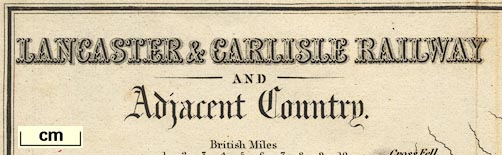
Map, Lancaster and Carlisle Railway and Adjacent Country,
through Lancashire, Westmorland and Cumberland, scale about
7.5 miles to 1 inch, by John Bartholomew, Edinburgh,
published by Adam and Charles Black, 27 North Bridge,
Edinburgh, Lothian, about 1850-52.
Included in a guide book, Black's Picturesque Guide to the English Lakes. |
||
|
(map example JandMN (82_2))
|
||
| map feature:- | north point & up is E & scale line & sea plain & coast line & coast form lines & rivers & lakes & relief & hill hachuring & parks & county & settlements & roads & railways & canals | |
| inscription:- |
printed upper left
LANCASTER & CARLISLE RAILWAY / AND / Adjacent Country |
|
| inscription:- |
printed bottom, centre and right
Published byAdam & Charles Black 27 North Bridge Edinburgh / Drawn & Engraved by J. Bartholomew Edinr. |
|
| inscription:- |
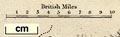
printed above scale line
British Miles |
|
| scale line:- | 10 miles = 33.1 mm | |
| scale:- | 1 to 490000 ? (1 to 486207 from scale line) | |
| wxh, sheet:- | 24.5x17cm | |
| wxh, map:- | 227x146mm | |
|
||
| sources:- |
JandMN Collection Wordsworth Trust Collection |
|
| items seen (illustrated items in bold):- | ||

|
Dove Cottage : 2007.38.75 -- railway map -- Lancaster and Carlisle Railway and Adjacent Country | |
|
|
JandMN (82_2) -- railway map -- Lancaster and Carlisle Railway and Adjacent Country | |